Gawanan geodata
Gawanan (Central Java) is a seat of a fourth-order administrative division; located in Indonesia in Asia/Jakarta (GMT+7) time zone. In our database, there are 407 cities with bigger population. Compared to other cities in Indonesia, 83.8% of cities are located further ↓South; 64.3% of cities are located further →East and 90.6% of cities have higher elevation than Gawanan. Note1


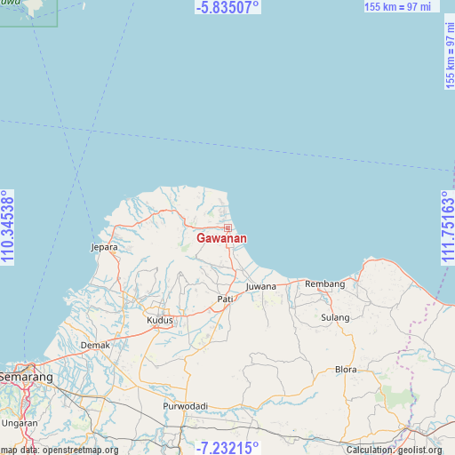
Gawanan GPS coordinates[2]
6° 32' 2.76" South, 111° 2' 54.6" East
| Map corner | latitude | longitude |
|---|---|---|
| Upper-left | -5.83507°, | 110.34538° |
| Center: | -6.5341°, | 111.0485° |
| Lower-right: | -7.23215°, | 111.75163° |
| Map W x H: | 155.3×155.3 km | = 96.5×96.5mi |
| max Lat: | 5.88969° ⇑16.2% North |
| Gawanan: | -6.5341° |
| min Lat: | ⇓83.8% South -10.934° |
| min Long | Gawanan | max Long |
| 95.1345° | 111.0485° | 140.9419° |
| W 35.7%⇐ | ⇒64.3% E |
Elevation
Elevation of Gawanan is 10 m = 33 ft, and this is 219.7 m = 721 ft below average elevation for this country.
| Max E: |
3185 m = 10449 ft | 90.6% |
| Avg. | 229.7 m = 754 ft | |
| Gawanan | 10 m = 33 ft | |
Min E: |
-1 m = -3 ft | 9.4% |
See also: Indonesia elevation on elevation.city.
Geographical zone
Gawanan is located in South Torrid zone (between Equator and Tropic of Capricorn). Distance of Equator is 726.5 km =451.4 mi to North.| Distance of | km | miles | from Gawanan |
|---|---|---|---|
| Equator | 726.5 | 451.4 | to North |
| Tropic Capricorn | 1879.4 | 1167.8 | to South |
| Antarctic Circle | 6674.7 | 4147.5 | to South |
| South Pole | 9280.5 | 5766.6 | to South |


Nearby cities:
15 places around Gawanan: (largest is in red/bold)
• Belah Lor
0.7 km =0.4 mi,  119°
119°
• Gondosari
3.2 km =2 mi,  289°
289°
• Jepat Kidul
2.6 km =1.6 mi,  171°
171°
• Kampunganyar
1.9 km =1.2 mi, 172°
• Kampunganyar
2.9 km =1.8 mi,  331°
331°
• Kedungbang
3.3 km =2.1 mi,  252°
252°
• Ketapang
3 km =1.9 mi,  203°
203°
• Krajan Keboromo
1.1 km =0.7 mi,  163°
163°
• Pecinan
0.8 km =0.5 mi,  68°
68°
• Pule
2.6 km =1.6 mi,  271°
271°
• Rowo
1.9 km =1.2 mi,  211°
211°
• Tayu
0.7 km =0.4 mi,  149°
149°
• Tayu Kulon
0.7 km =0.4 mi,  259°
259°
• Tunggulsari
2.5 km =1.6 mi, 151°
• Winong
2 km =1.2 mi,  319°
319°
Sources, notices
• [Note1] Compared only with cities in Indonesia existing in our database
• [Src1] Map data: © OpenStreetMap contributors (CC-BY-SA)
• [Src2] Other city data from geonames.org with taken over terms of usage.
• [Src3] Geographical zone / Annual Mean Temperature by Robert A. Rohde @ Wikipedia
