Langkaplancar geodata
Langkaplancar (West Java) is a seat of a fourth-order administrative division; located in Indonesia in Asia/Jakarta (GMT+7) time zone. In our database, there are 407 cities with bigger population. Compared to other cities in Indonesia, 52.5% of cities are located further ↑North; 70% of cities are located further →East and 80.9% of cities have higher elevation than Langkaplancar. Note1


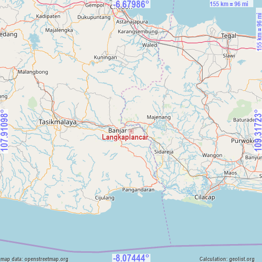
Langkaplancar GPS coordinates[2]
7° 22' 39.72" South, 108° 36' 50.76" East
| Map corner | latitude | longitude |
|---|---|---|
| Upper-left | -6.67986°, | 107.91098° |
| Center: | -7.3777°, | 108.6141° |
| Lower-right: | -8.07444°, | 109.31723° |
| Map W x H: | 155.1×155.1 km | = 96.4×96.4mi |
| max Lat: | 5.88969° ⇑52.5% North |
| Langkaplancar: | -7.3777° |
| min Lat: | ⇓47.5% South -10.934° |
| min Long | Langkaplancar | max Long |
| 95.1345° | 108.6141° | 140.9419° |
| W 30%⇐ | ⇒70% E |
Elevation
Elevation of Langkaplancar is 18 m = 59 ft, and this is 211.7 m = 695 ft below average elevation for this country.
| Max E: |
3185 m = 10449 ft | 80.9% |
| Avg. | 229.7 m = 754 ft | |
| Langkaplancar | 18 m = 59 ft | |
Min E: |
-1 m = -3 ft | 19.1% |
See also: Indonesia elevation on elevation.city.
Geographical zone
Langkaplancar is located in South Torrid zone (between Equator and Tropic of Capricorn). Distance of Equator is 820.3 km =509.7 mi to North.| Distance of | km | miles | from Langkaplancar |
|---|---|---|---|
| Equator | 820.3 | 509.7 | to North |
| Tropic Capricorn | 1785.6 | 1109.5 | to South |
| Antarctic Circle | 6580.9 | 4089.2 | to South |
| South Pole | 9186.7 | 5708.3 | to South |


Nearby cities:
15 places around Langkaplancar: (largest is in red/bold)
• Babakan
3.2 km =2 mi,  65°
65°
• Bobojong
4.5 km =2.8 mi,  223°
223°
• Cijurey
2.1 km =1.3 mi,  209°
209°
• Kalapagada
5.5 km =3.4 mi,  109°
109°
• Lakbok
5.6 km =3.5 mi,  121°
121°
• Rancakole
2.8 km =1.7 mi,  284°
284°
• Randegan
5.5 km =3.4 mi,  300°
300°
• Randegan Dua
5.6 km =3.5 mi, 295°
• Sinargalih
3.5 km =2.2 mi,  49°
49°
• Sindanggalih
2.1 km =1.3 mi,  30°
30°
• Sukahurip
3.8 km =2.4 mi,  40°
40°
• Sukamukti
3.5 km =2.2 mi,  178°
178°
• Sukanagara
5.4 km =3.4 mi, 122°
• Sukaratu
4.9 km =3 mi,  185°
185°
• Tambakreja
4.7 km =2.9 mi,  96°
96°
Sources, notices
• [Note1] Compared only with cities in Indonesia existing in our database
• [Src1] Map data: © OpenStreetMap contributors (CC-BY-SA)
• [Src2] Other city data from geonames.org with taken over terms of usage.
• [Src3] Geographical zone / Annual Mean Temperature by Robert A. Rohde @ Wikipedia
