Bungasrejo geodata
Bungasrejo (Central Java) is a seat of a fourth-order administrative division; located in Indonesia in Asia/Jakarta (GMT+7) time zone. In our database, there are 407 cities with bigger population. Compared to other cities in Indonesia, 78.6% of cities are located further ↓South; 63.4% of cities are located further →East and 92.1% of cities have higher elevation than Bungasrejo. Note1


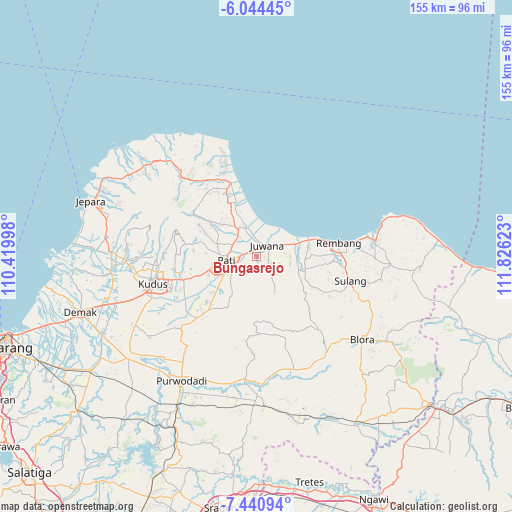
Bungasrejo GPS coordinates[2]
6° 44' 35.52" South, 111° 7' 23.16" East
| Map corner | latitude | longitude |
|---|---|---|
| Upper-left | -6.04445°, | 110.41998° |
| Center: | -6.7432°, | 111.1231° |
| Lower-right: | -7.44094°, | 111.82623° |
| Map W x H: | 155.3×155.3 km | = 96.5×96.5mi |
| max Lat: | 5.88969° ⇑21.4% North |
| Bungasrejo: | -6.7432° |
| min Lat: | ⇓78.6% South -10.934° |
| min Long | Bungasrejo | max Long |
| 95.1345° | 111.1231° | 140.9419° |
| W 36.6%⇐ | ⇒63.4% E |
Elevation
Elevation of Bungasrejo is 9 m = 30 ft, and this is 220.7 m = 724 ft below average elevation for this country.
| Max E: |
3185 m = 10449 ft | 92.1% |
| Avg. | 229.7 m = 754 ft | |
| Bungasrejo | 9 m = 30 ft | |
Min E: |
-1 m = -3 ft | 7.9% |
See also: Indonesia elevation on elevation.city.
Geographical zone
Bungasrejo is located in South Torrid zone (between Equator and Tropic of Capricorn). Distance of Equator is 749.8 km =465.9 mi to North.| Distance of | km | miles | from Bungasrejo |
|---|---|---|---|
| Equator | 749.8 | 465.9 | to North |
| Tropic Capricorn | 1856.1 | 1153.3 | to South |
| Antarctic Circle | 6651.4 | 4133 | to South |
| South Pole | 9257.3 | 5752.2 | to South |


Nearby cities:
15 places around Bungasrejo: (largest is in red/bold)
• Bagu
2 km =1.2 mi,  20°
20°
• Batur Kidul
2.1 km =1.3 mi,  137°
137°
• Daulan
3.3 km =2.1 mi,  153°
153°
• Doropayung
3.4 km =2.1 mi,  42°
42°
• Druju
0.8 km =0.5 mi,  110°
110°
• Glonggong
1.1 km =0.7 mi,  178°
178°
• Guwo
2.4 km =1.5 mi,  306°
306°
• Jepuro
2.9 km =1.8 mi,  54°
54°
• Karangboyo
3.5 km =2.2 mi,  68°
68°
• Kedungpancing
3.3 km =2.1 mi, 51°
• Kijingan
1.3 km =0.8 mi,  215°
215°
• Pencil
1 km =0.6 mi,  283°
283°
• Sejomulyo
2.2 km =1.4 mi,  89°
89°
• Tlogocilik
2.5 km =1.6 mi,  233°
233°
• Tluwah
2.7 km =1.7 mi,  59°
59°
Sources, notices
• [Note1] Compared only with cities in Indonesia existing in our database
• [Src1] Map data: © OpenStreetMap contributors (CC-BY-SA)
• [Src2] Other city data from geonames.org with taken over terms of usage.
• [Src3] Geographical zone / Annual Mean Temperature by Robert A. Rohde @ Wikipedia
