Asempapan geodata
Asempapan (Central Java) is a seat of a fourth-order administrative division; located in Indonesia in Asia/Jakarta (GMT+7) time zone. In our database, there are 407 cities with bigger population. Compared to other cities in Indonesia, 81.5% of cities are located further ↓South; 63.5% of cities are located further →East and 93.7% of cities have higher elevation than Asempapan. Note1


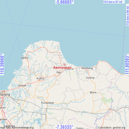
Asempapan GPS coordinates[2]
6° 40' 3.72" South, 111° 6' 10.08" East
| Map corner | latitude | longitude |
|---|---|---|
| Upper-left | -5.96885°, | 110.39968° |
| Center: | -6.6677°, | 111.1028° |
| Lower-right: | -7.36555°, | 111.80593° |
| Map W x H: | 155.3×155.3 km | = 96.5×96.5mi |
| max Lat: | 5.88969° ⇑18.5% North |
| Asempapan: | -6.6677° |
| min Lat: | ⇓81.5% South -10.934° |
| min Long | Asempapan | max Long |
| 95.1345° | 111.1028° | 140.9419° |
| W 36.5%⇐ | ⇒63.5% E |
Elevation
Elevation of Asempapan is 8 m = 26 ft, and this is 221.7 m = 727 ft below average elevation for this country.
| Max E: |
3185 m = 10449 ft | 93.7% |
| Avg. | 229.7 m = 754 ft | |
| Asempapan | 8 m = 26 ft | |
Min E: |
-1 m = -3 ft | 6.3% |
See also: Indonesia elevation on elevation.city.
Geographical zone
Asempapan is located in South Torrid zone (between Equator and Tropic of Capricorn). Distance of Equator is 741.4 km =460.7 mi to North.| Distance of | km | miles | from Asempapan |
|---|---|---|---|
| Equator | 741.4 | 460.7 | to North |
| Tropic Capricorn | 1864.5 | 1158.5 | to South |
| Antarctic Circle | 6659.8 | 4138.2 | to South |
| South Pole | 9265.7 | 5757.4 | to South |


Nearby cities:
15 places around Asempapan: (largest is in red/bold)
• Bonagung
1.7 km =1.1 mi,  296°
296°
• Dodol
1.7 km =1.1 mi,  178°
178°
• Geneng
1.6 km =1 mi,  336°
336°
• Geneng Tengah
2.9 km =1.8 mi,  133°
133°
• Guyangan
1 km =0.6 mi,  333°
333°
• Jetak
0.7 km =0.4 mi,  223°
223°
• Jetak Kulon
1.5 km =0.9 mi,  242°
242°
• Kepoh
0.9 km =0.6 mi,  168°
168°
• Krandan
2.8 km =1.7 mi,  309°
309°
• Pagerharjo
2.3 km =1.4 mi, 236°
• Pentungan
2.7 km =1.7 mi,  162°
162°
• Sambilawang
0.8 km =0.5 mi,  357°
357°
• Tlogoharum
0.4 km =0.2 mi,  124°
124°
• Tlutup
2.6 km =1.6 mi,  323°
323°
• Tluwuk
1.9 km =1.2 mi, 130°
Sources, notices
• [Note1] Compared only with cities in Indonesia existing in our database
• [Src1] Map data: © OpenStreetMap contributors (CC-BY-SA)
• [Src2] Other city data from geonames.org with taken over terms of usage.
• [Src3] Geographical zone / Annual Mean Temperature by Robert A. Rohde @ Wikipedia
