Growong Lor geodata
Growong Lor (Central Java) is a seat of a fourth-order administrative division; located in Indonesia in Asia/Jakarta (GMT+7) time zone. In our database, there are 407 cities with bigger population. Compared to other cities in Indonesia, 80% of cities are located further ↓South; 63.2% of cities are located further →East and 95.5% of cities have higher elevation than Growong Lor. Note1


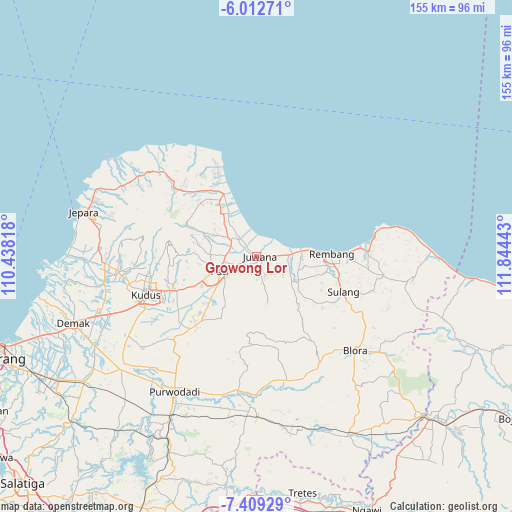
Growong Lor GPS coordinates[2]
6° 42' 41.4" South, 111° 8' 28.68" East
| Map corner | latitude | longitude |
|---|---|---|
| Upper-left | -6.01271°, | 110.43818° |
| Center: | -6.7115°, | 111.1413° |
| Lower-right: | -7.40929°, | 111.84443° |
| Map W x H: | 155.3×155.3 km | = 96.5×96.5mi |
| max Lat: | 5.88969° ⇑20% North |
| Growong Lor: | -6.7115° |
| min Lat: | ⇓80% South -10.934° |
| min Long | Growong Lor | max Long |
| 95.1345° | 111.1413° | 140.9419° |
| W 36.8%⇐ | ⇒63.2% E |
Elevation
Elevation of Growong Lor is 7 m = 23 ft, and this is 222.7 m = 731 ft below average elevation for this country.
| Max E: |
3185 m = 10449 ft | 95.5% |
| Avg. | 229.7 m = 754 ft | |
| Growong Lor | 7 m = 23 ft | |
Min E: |
-1 m = -3 ft | 4.5% |
See also: Indonesia elevation on elevation.city.
Geographical zone
Growong Lor is located in South Torrid zone (between Equator and Tropic of Capricorn). Distance of Equator is 746.2 km =463.7 mi to North.| Distance of | km | miles | from Growong Lor |
|---|---|---|---|
| Equator | 746.2 | 463.7 | to North |
| Tropic Capricorn | 1859.7 | 1155.6 | to South |
| Antarctic Circle | 6654.9 | 4135.2 | to South |
| South Pole | 9260.8 | 5754.4 | to South |


Nearby cities:
15 places around Growong Lor: (largest is in red/bold)
• Bajomulyo
1.1 km =0.7 mi,  85°
85°
• Bakaran Kulon
1.9 km =1.2 mi,  294°
294°
• Bakaran Wetan
0.8 km =0.5 mi,  310°
310°
• Bendar
1.6 km =1 mi,  81°
81°
• Doropayung
1 km =0.6 mi,  163°
163°
• Dukutalit
0.6 km =0.4 mi, 294°
• Growong Kidul
0.5 km =0.3 mi,  224°
224°
• Jepuro
1.9 km =1.2 mi,  168°
168°
• Juwana
1.2 km =0.7 mi,  109°
109°
• Kauman
0.8 km =0.5 mi,  142°
142°
• Kebonsawahan
0.5 km =0.3 mi, 81°
• Kedungpancing
1.6 km =1 mi, 159°
• Kudukeras
0.9 km =0.6 mi,  102°
102°
• Pajeksan
0.5 km =0.3 mi,  120°
120°
• Pulorejo
1.3 km =0.8 mi,  149°
149°
Sources, notices
• [Note1] Compared only with cities in Indonesia existing in our database
• [Src1] Map data: © OpenStreetMap contributors (CC-BY-SA)
• [Src2] Other city data from geonames.org with taken over terms of usage.
• [Src3] Geographical zone / Annual Mean Temperature by Robert A. Rohde @ Wikipedia
