Gayamsari geodata
Gayamsari (Central Java) is a seat of a fourth-order administrative division; located in Indonesia in Asia/Jakarta (GMT+7) time zone. In our database, there are 407 cities with bigger population. Compared to other cities in Indonesia, 54.3% of cities are located further ↑North; 68.6% of cities are located further →East and 85.2% of cities have higher elevation than Gayamsari. Note1


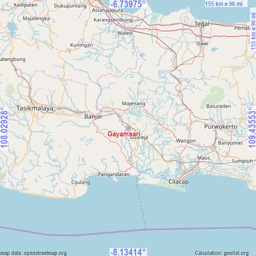
Gayamsari GPS coordinates[2]
7° 26' 15" South, 108° 43' 56.64" East
| Map corner | latitude | longitude |
|---|---|---|
| Upper-left | -6.73975°, | 108.02928° |
| Center: | -7.4375°, | 108.7324° |
| Lower-right: | -8.13414°, | 109.43553° |
| Map W x H: | 155×155 km | = 96.3×96.3mi |
| max Lat: | 5.88969° ⇑54.3% North |
| Gayamsari: | -7.4375° |
| min Lat: | ⇓45.7% South -10.934° |
| min Long | Gayamsari | max Long |
| 95.1345° | 108.7324° | 140.9419° |
| W 31.4%⇐ | ⇒68.6% E |
Elevation
Elevation of Gayamsari is 14 m = 46 ft, and this is 215.7 m = 708 ft below average elevation for this country.
| Max E: |
3185 m = 10449 ft | 85.2% |
| Avg. | 229.7 m = 754 ft | |
| Gayamsari | 14 m = 46 ft | |
Min E: |
-1 m = -3 ft | 14.8% |
See also: Indonesia elevation on elevation.city.
Geographical zone
Gayamsari is located in South Torrid zone (between Equator and Tropic of Capricorn). Distance of Equator is 827 km =513.9 mi to North.| Distance of | km | miles | from Gayamsari |
|---|---|---|---|
| Equator | 827 | 513.9 | to North |
| Tropic Capricorn | 1778.9 | 1105.4 | to South |
| Antarctic Circle | 6574.2 | 4085 | to South |
| South Pole | 9180.1 | 5704.2 | to South |


Nearby cities:
15 places around Gayamsari: (largest is in red/bold)
• Candimulya
1.9 km =1.2 mi,  74°
74°
• Cibatu
4.5 km =2.8 mi,  41°
41°
• Cilongkrang
3.9 km =2.4 mi,  326°
326°
• Cipari
3.4 km =2.1 mi,  92°
92°
• Cisuru
4.4 km =2.7 mi,  6°
6°
• Dukuhsawah
5.5 km =3.4 mi,  95°
95°
• Jamban
4.5 km =2.8 mi,  294°
294°
• Karangtengah
3.3 km =2.1 mi, 100°
• Margasari
3.6 km =2.2 mi,  157°
157°
• Pasirgaru
2.1 km =1.3 mi,  183°
183°
• Prumpung
4.4 km =2.7 mi,  130°
130°
• Rejamulya
4.7 km =2.9 mi,  167°
167°
• Sarimukti Kaler
2.1 km =1.3 mi, 292°
• Sawangan
4.5 km =2.8 mi,  22°
22°
• Talangbanteng
3.3 km =2.1 mi,  254°
254°
Sources, notices
• [Note1] Compared only with cities in Indonesia existing in our database
• [Src1] Map data: © OpenStreetMap contributors (CC-BY-SA)
• [Src2] Other city data from geonames.org with taken over terms of usage.
• [Src3] Geographical zone / Annual Mean Temperature by Robert A. Rohde @ Wikipedia
