Gondang geodata
Gondang (Central Java) is a seat of a fourth-order administrative division; located in Indonesia in Asia/Jakarta (GMT+7) time zone. In our database, there are 407 cities with bigger population. Compared to other cities in Indonesia, 77.9% of cities are located further ↓South; 59.7% of cities are located further →East and 73.4% of cities have higher elevation than Gondang. Note1


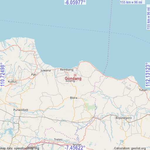
Gondang GPS coordinates[2]
6° 45' 30.6" South, 111° 25' 41.16" East
| Map corner | latitude | longitude |
|---|---|---|
| Upper-left | -6.05977°, | 110.72498° |
| Center: | -6.7585°, | 111.4281° |
| Lower-right: | -7.45622°, | 112.13123° |
| Map W x H: | 155.3×155.3 km | = 96.5×96.5mi |
| max Lat: | 5.88969° ⇑22.1% North |
| Gondang: | -6.7585° |
| min Lat: | ⇓77.9% South -10.934° |
| min Long | Gondang | max Long |
| 95.1345° | 111.4281° | 140.9419° |
| W 40.3%⇐ | ⇒59.7% E |
Elevation
Elevation of Gondang is 27 m = 89 ft, and this is 202.7 m = 665 ft below average elevation for this country.
| Max E: |
3185 m = 10449 ft | 73.4% |
| Avg. | 229.7 m = 754 ft | |
| Gondang | 27 m = 89 ft | |
Min E: |
-1 m = -3 ft | 26.6% |
See also: Indonesia elevation on elevation.city.
Geographical zone
Gondang is located in South Torrid zone (between Equator and Tropic of Capricorn). Distance of Equator is 751.5 km =467 mi to North.| Distance of | km | miles | from Gondang |
|---|---|---|---|
| Equator | 751.5 | 467 | to North |
| Tropic Capricorn | 1854.4 | 1152.3 | to South |
| Antarctic Circle | 6649.7 | 4131.9 | to South |
| South Pole | 9255.6 | 5751.2 | to South |


Nearby cities:
15 places around Gondang: (largest is in red/bold)
• Japeledok
2.1 km =1.3 mi,  42°
42°
• Japerejo
2.6 km =1.6 mi,  67°
67°
• Jeruk
2.9 km =1.8 mi,  28°
28°
• Kembang
1.5 km =0.9 mi,  166°
166°
• Kepohagung
1.5 km =0.9 mi,  214°
214°
• Ketangi
2.5 km =1.6 mi,  297°
297°
• Korowelang
3.6 km =2.2 mi,  198°
198°
• Mlagen
2.8 km =1.7 mi,  188°
188°
• Mlawat
2.2 km =1.4 mi, 211°
• Pandan
3.7 km =2.3 mi, 41°
• Segoro
2 km =1.2 mi,  239°
239°
• Sendangagung
1.6 km =1 mi,  346°
346°
• Tempaling
2.8 km =1.7 mi,  131°
131°
• Tempel
3.7 km =2.3 mi,  143°
143°
• Tulung
3.3 km =2.1 mi,  61°
61°
Sources, notices
• [Note1] Compared only with cities in Indonesia existing in our database
• [Src1] Map data: © OpenStreetMap contributors (CC-BY-SA)
• [Src2] Other city data from geonames.org with taken over terms of usage.
• [Src3] Geographical zone / Annual Mean Temperature by Robert A. Rohde @ Wikipedia
