Potlot geodata
Potlot (Central Java) is a seat of a fourth-order administrative division; located in Indonesia in Asia/Jakarta (GMT+7) time zone. In our database, there are 407 cities with bigger population. Compared to other cities in Indonesia, 68% of cities are located further ↓South; 60.2% of cities are located further →East and 54% of cities have higher elevation than Potlot. Note1


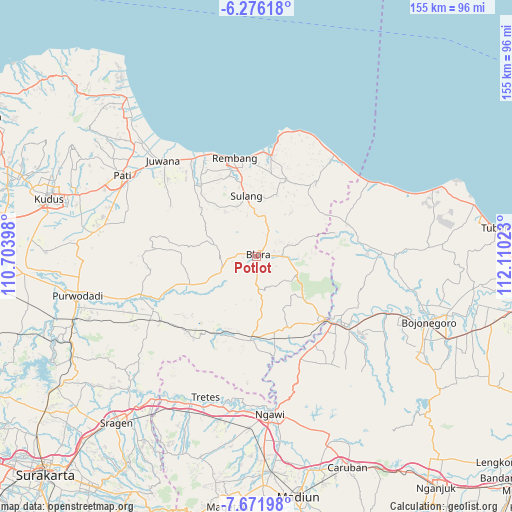
Potlot GPS coordinates[2]
6° 58' 28.56" South, 111° 24' 25.56" East
| Map corner | latitude | longitude |
|---|---|---|
| Upper-left | -6.27618°, | 110.70398° |
| Center: | -6.9746°, | 111.4071° |
| Lower-right: | -7.67198°, | 112.11023° |
| Map W x H: | 155.2×155.2 km | = 96.4×96.4mi |
| max Lat: | 5.88969° ⇑32% North |
| Potlot: | -6.9746° |
| min Lat: | ⇓68% South -10.934° |
| min Long | Potlot | max Long |
| 95.1345° | 111.4071° | 140.9419° |
| W 39.8%⇐ | ⇒60.2% E |
Elevation
Elevation of Potlot is 89 m = 292 ft, and this is 140.7 m = 462 ft below average elevation for this country.
| Max E: |
3185 m = 10449 ft | 54% |
| Avg. | 229.7 m = 754 ft | |
| Potlot | 89 m = 292 ft | |
Min E: |
-1 m = -3 ft | 46% |
See also: Indonesia elevation on elevation.city.
Geographical zone
Potlot is located in South Torrid zone (between Equator and Tropic of Capricorn). Distance of Equator is 775.5 km =481.9 mi to North.| Distance of | km | miles | from Potlot |
|---|---|---|---|
| Equator | 775.5 | 481.9 | to North |
| Tropic Capricorn | 1830.4 | 1137.4 | to South |
| Antarctic Circle | 6625.7 | 4117 | to South |
| South Pole | 9231.6 | 5736.2 | to South |


Nearby cities:
15 places around Potlot: (largest is in red/bold)
• Bangeran
2.3 km =1.4 mi,  163°
163°
• Bangkle
2.6 km =1.6 mi,  80°
80°
• Beran
0.6 km =0.4 mi,  146°
146°
• Blora
1.4 km =0.9 mi,  67°
67°
• Jetis
0.4 km =0.2 mi,  120°
120°
• Kajangansawan
1 km =0.6 mi,  304°
304°
• Karangjati
3 km =1.9 mi,  45°
45°
• Karangnongko
1.8 km =1.1 mi,  218°
218°
• Kauman
0.6 km =0.4 mi,  13°
13°
• Kedungjenar
1.5 km =0.9 mi,  94°
94°
• Kunden
1.4 km =0.9 mi,  20°
20°
• Mlangsen
0.9 km =0.6 mi, 86°
• Tegalgunung
2 km =1.2 mi,  41°
41°
• Tempelan
1.4 km =0.9 mi, 43°
• Tutup
1.9 km =1.2 mi,  283°
283°
Sources, notices
• [Note1] Compared only with cities in Indonesia existing in our database
• [Src1] Map data: © OpenStreetMap contributors (CC-BY-SA)
• [Src2] Other city data from geonames.org with taken over terms of usage.
• [Src3] Geographical zone / Annual Mean Temperature by Robert A. Rohde @ Wikipedia
