Cileuya geodata
Cileuya (West Java) is a seat of a fourth-order administrative division; located in Indonesia in Asia/Jakarta (GMT+7) time zone. In our database, there are 407 cities with bigger population. Compared to other cities in Indonesia, 64.3% of cities are located further ↓South; 69.2% of cities are located further →East and 50.3% of cities have higher elevation than Cileuya. Note1


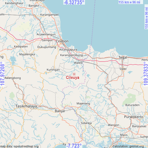
Cileuya GPS coordinates[2]
7° 1' 32.52" South, 108° 40' 30.72" East
| Map corner | latitude | longitude |
|---|---|---|
| Upper-left | -6.32735°, | 107.97208° |
| Center: | -7.0257°, | 108.6752° |
| Lower-right: | -7.723°, | 109.37833° |
| Map W x H: | 155.2×155.2 km | = 96.4×96.4mi |
| max Lat: | 5.88969° ⇑35.7% North |
| Cileuya: | -7.0257° |
| min Lat: | ⇓64.3% South -10.934° |
| min Long | Cileuya | max Long |
| 95.1345° | 108.6752° | 140.9419° |
| W 30.8%⇐ | ⇒69.2% E |
Elevation
Elevation of Cileuya is 101 m = 331 ft, and this is 128.7 m = 422 ft below average elevation for this country.
| Max E: |
3185 m = 10449 ft | 50.3% |
| Avg. | 229.7 m = 754 ft | |
| Cileuya | 101 m = 331 ft | |
Min E: |
-1 m = -3 ft | 49.7% |
See also: Indonesia elevation on elevation.city.
Geographical zone
Cileuya is located in South Torrid zone (between Equator and Tropic of Capricorn). Distance of Equator is 781.2 km =485.4 mi to North.| Distance of | km | miles | from Cileuya |
|---|---|---|---|
| Equator | 781.2 | 485.4 | to North |
| Tropic Capricorn | 1824.7 | 1133.8 | to South |
| Antarctic Circle | 6620 | 4113.5 | to South |
| South Pole | 9225.9 | 5732.7 | to South |


Nearby cities:
15 places around Cileuya: (largest is in red/bold)
• Andamui
2.9 km =1.8 mi,  241°
241°
• Baok
4.3 km =2.7 mi,  250°
250°
• Cigedang
4.4 km =2.7 mi,  266°
266°
• Cikadu Wetan
1.2 km =0.7 mi,  301°
301°
• Dukuhmaja
3.6 km =2.2 mi, 303°
• Garajati
4.9 km =3 mi, 236°
• Kawungsari
5.2 km =3.2 mi,  154°
154°
• Luragung
4.2 km =2.6 mi,  282°
282°
• Luragung Tonggoh
4.4 km =2.7 mi, 277°
• Pahing Margamukti
2 km =1.2 mi,  45°
45°
• Pakusari
4.6 km =2.9 mi,  58°
58°
• Randusari
4.9 km =3 mi,  130°
130°
• Sindangsuka
5 km =3.1 mi,  290°
290°
• Sukagalih
4.1 km =2.5 mi,  172°
172°
• Tanjungkerta
5 km =3.1 mi,  178°
178°
Sources, notices
• [Note1] Compared only with cities in Indonesia existing in our database
• [Src1] Map data: © OpenStreetMap contributors (CC-BY-SA)
• [Src2] Other city data from geonames.org with taken over terms of usage.
• [Src3] Geographical zone / Annual Mean Temperature by Robert A. Rohde @ Wikipedia
