Jahulu geodata
Jahulu (East Java) is a seat of a fourth-order administrative division; located in Indonesia in Asia/Jakarta (GMT+7) time zone. In our database, there are 407 cities with bigger population. Compared to other cities in Indonesia, 75.9% of cities are located further ↓South; 53.6% of cities are located further →East and 69.5% of cities have higher elevation than Jahulu. Note1


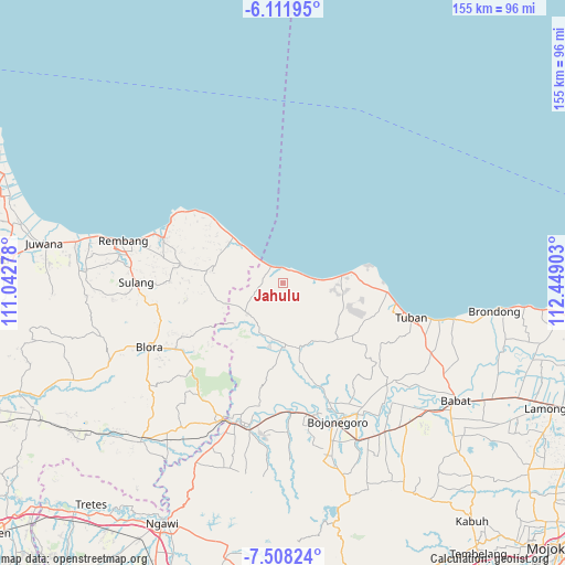
Jahulu GPS coordinates[2]
6° 48' 38.16" South, 111° 44' 45.24" East
| Map corner | latitude | longitude |
|---|---|---|
| Upper-left | -6.11195°, | 111.04278° |
| Center: | -6.8106°, | 111.7459° |
| Lower-right: | -7.50824°, | 112.44903° |
| Map W x H: | 155.3×155.3 km | = 96.5×96.5mi |
| max Lat: | 5.88969° ⇑24.1% North |
| Jahulu: | -6.8106° |
| min Lat: | ⇓75.9% South -10.934° |
| min Long | Jahulu | max Long |
| 95.1345° | 111.7459° | 140.9419° |
| W 46.4%⇐ | ⇒53.6% E |
Elevation
Elevation of Jahulu is 33 m = 108 ft, and this is 196.7 m = 645 ft below average elevation for this country.
| Max E: |
3185 m = 10449 ft | 69.5% |
| Avg. | 229.7 m = 754 ft | |
| Jahulu | 33 m = 108 ft | |
Min E: |
-1 m = -3 ft | 30.5% |
See also: Indonesia elevation on elevation.city.
Geographical zone
Jahulu is located in South Torrid zone (between Equator and Tropic of Capricorn). Distance of Equator is 757.3 km =470.6 mi to North.| Distance of | km | miles | from Jahulu |
|---|---|---|---|
| Equator | 757.3 | 470.6 | to North |
| Tropic Capricorn | 1848.7 | 1148.7 | to South |
| Antarctic Circle | 6643.9 | 4128.3 | to South |
| South Pole | 9249.8 | 5747.6 | to South |


Nearby cities:
15 places around Jahulu: (largest is in red/bold)
• Bancar
4.9 km =3 mi,  51°
51°
• Banjarjo
4.8 km =3 mi,  332°
332°
• Boncong
4.4 km =2.7 mi,  345°
345°
• Bulumeduro
4.6 km =2.9 mi,  338°
338°
• Jatisari
1.8 km =1.1 mi,  204°
204°
• Kayen
1.7 km =1.1 mi, 197°
• Kelabang
4 km =2.5 mi, 329°
• Mojoroto
3.7 km =2.3 mi,  91°
91°
• Ngembak
4.2 km =2.6 mi,  35°
35°
• Pugoh
2.7 km =1.7 mi, 88°
• Sedandang
2 km =1.2 mi,  110°
110°
• Sembungin
1.9 km =1.2 mi,  25°
25°
• Siding
2.1 km =1.3 mi,  308°
308°
• Simo
3.4 km =2.1 mi, 110°
• Tengger
4.2 km =2.6 mi,  293°
293°
Sources, notices
• [Note1] Compared only with cities in Indonesia existing in our database
• [Src1] Map data: © OpenStreetMap contributors (CC-BY-SA)
• [Src2] Other city data from geonames.org with taken over terms of usage.
• [Src3] Geographical zone / Annual Mean Temperature by Robert A. Rohde @ Wikipedia
