Broto geodata
Broto (East Java) is a seat of a fourth-order administrative division; located in Indonesia in Asia/Jakarta (GMT+7) time zone. In our database, there are 407 cities with bigger population. Compared to other cities in Indonesia, 62.1% of cities are located further ↑North; 60.1% of cities are located further →East and 58.5% of cities have lower elevation than Broto. Note1


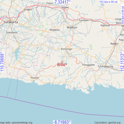
Broto GPS coordinates[2]
8° 1' 15.6" South, 111° 24' 36" East
| Map corner | latitude | longitude |
|---|---|---|
| Upper-left | -7.32417°, | 110.70688° |
| Center: | -8.021°, | 111.41° |
| Lower-right: | -8.71663°, | 112.11313° |
| Map W x H: | 154.8×154.8 km | = 96.2×96.2mi |
| max Lat: | 5.88969° ⇑62.1% North |
| Broto: | -8.021° |
| min Lat: | ⇓37.9% South -10.934° |
| min Long | Broto | max Long |
| 95.1345° | 111.41° | 140.9419° |
| W 39.9%⇐ | ⇒60.1% E |
Elevation
Elevation of Broto is 150 m = 492 ft, and this is 79.7 m = 261 ft below average elevation for this country.
| Max E: |
3185 m = 10449 ft | 41.5% |
| Avg. | 229.7 m = 754 ft | |
| Broto | 150 m = 492 ft | |
Min E: |
-1 m = -3 ft | 58.5% |
See also: Indonesia elevation on elevation.city.
Geographical zone
Broto is located in South Torrid zone (between Equator and Tropic of Capricorn). Distance of Equator is 891.9 km =554.2 mi to North.| Distance of | km | miles | from Broto |
|---|---|---|---|
| Equator | 891.9 | 554.2 | to North |
| Tropic Capricorn | 1714.1 | 1065.1 | to South |
| Antarctic Circle | 6509.3 | 4044.7 | to South |
| South Pole | 9115.2 | 5663.9 | to South |


Nearby cities:
15 places around Broto: (largest is in red/bold)
• Banggel
2.5 km =1.6 mi,  31°
31°
• Beluk
4.4 km =2.7 mi,  64°
64°
• Bugis
3.8 km =2.4 mi,  87°
87°
• Dawang
1.7 km =1.1 mi,  162°
162°
• Gabahan
4.7 km =2.9 mi, 86°
• Krajan Caluk
2.3 km =1.4 mi,  215°
215°
• Krajan Menggare
1.1 km =0.7 mi,  42°
42°
• Krajan Senepo
3.1 km =1.9 mi, 216°
• Krajan Tengah
3.4 km =2.1 mi,  278°
278°
• Krajan Tugurejo
2.8 km =1.7 mi,  233°
233°
• Maron
2.1 km =1.3 mi, 37°
• Melikan
1.7 km =1.1 mi,  15°
15°
• Nambak Tengah
4.2 km =2.6 mi,  71°
71°
• Setono
2.8 km =1.7 mi, 59°
• Slahung
1.6 km =1 mi, 164°
Sources, notices
• [Note1] Compared only with cities in Indonesia existing in our database
• [Src1] Map data: © OpenStreetMap contributors (CC-BY-SA)
• [Src2] Other city data from geonames.org with taken over terms of usage.
• [Src3] Geographical zone / Annual Mean Temperature by Robert A. Rohde @ Wikipedia
