Rejoagung geodata
Rejoagung (East Java) is a seat of a fourth-order administrative division; located in Indonesia in Asia/Jakarta (GMT+7) time zone. In our database, there are 407 cities with bigger population. Compared to other cities in Indonesia, 85.7% of cities are located further ↑North; 67.7% of cities are located further ←West and 84.2% of cities have higher elevation than Rejoagung. Note1


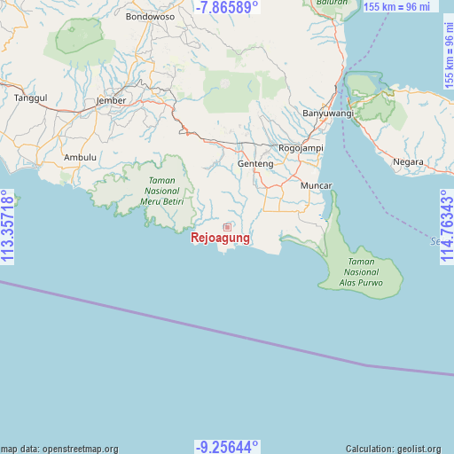
Rejoagung GPS coordinates[2]
8° 33' 42.48" South, 114° 3' 37.08" East
| Map corner | latitude | longitude |
|---|---|---|
| Upper-left | -7.86589°, | 113.35718° |
| Center: | -8.5618°, | 114.0603° |
| Lower-right: | -9.25644°, | 114.76343° |
| Map W x H: | 154.6×154.6 km | = 96.1×96.1mi |
| max Lat: | 5.88969° ⇑85.7% North |
| Rejoagung: | -8.5618° |
| min Lat: | ⇓14.3% South -10.934° |
| min Long | Rejoagung | max Long |
| 95.1345° | 114.0603° | 140.9419° |
| W 67.7%⇐ | ⇒32.3% E |
Elevation
Elevation of Rejoagung is 15 m = 49 ft, and this is 214.7 m = 704 ft below average elevation for this country.
| Max E: |
3185 m = 10449 ft | 84.2% |
| Avg. | 229.7 m = 754 ft | |
| Rejoagung | 15 m = 49 ft | |
Min E: |
-1 m = -3 ft | 15.8% |
See also: Indonesia elevation on elevation.city.
Geographical zone
Rejoagung is located in South Torrid zone (between Equator and Tropic of Capricorn). Distance of Equator is 952 km =591.5 mi to North.| Distance of | km | miles | from Rejoagung |
|---|---|---|---|
| Equator | 952 | 591.5 | to North |
| Tropic Capricorn | 1653.9 | 1027.7 | to South |
| Antarctic Circle | 6449.2 | 4007.3 | to South |
| South Pole | 9055.1 | 5626.6 | to South |


Nearby cities:
15 places around Rejoagung: (largest is in red/bold)
• Barurejo
10.7 km =6.6 mi,  33°
33°
• Blokagung
14.4 km =8.9 mi,  19°
19°
• Kandangan
10.1 km =6.3 mi,  282°
282°
• Kedungrejo
13.4 km =8.3 mi,  66°
66°
• Krajan
11 km =6.8 mi, 73°
• Mulyosari
3.3 km =2.1 mi,  85°
85°
• Pasembon
12.2 km =7.6 mi,  60°
60°
• Pesanggaran
4.4 km =2.7 mi,  102°
102°
• Purwoharjo
19 km =11.8 mi, 69°
• Sarongan
11.2 km =7 mi, 281°
• Selorejo
14.8 km =9.2 mi, 73°
• Sidorukun
7.2 km =4.5 mi,  115°
115°
• Siliragung
5.7 km =3.5 mi, 85°
• Sukorejo
8.6 km =5.3 mi,  43°
43°
• Sumberbening
6 km =3.7 mi, 65°
Sources, notices
• [Note1] Compared only with cities in Indonesia existing in our database
• [Src1] Map data: © OpenStreetMap contributors (CC-BY-SA)
• [Src2] Other city data from geonames.org with taken over terms of usage.
• [Src3] Geographical zone / Annual Mean Temperature by Robert A. Rohde @ Wikipedia
