Sumberpandan geodata
Sumberpandan (East Java) is a seat of a fourth-order administrative division; located in Indonesia in Asia/Jakarta (GMT+7) time zone. In our database, there are 407 cities with bigger population. Compared to other cities in Indonesia, 59.7% of cities are located further ↓South; 64.6% of cities are located further ←West and 70.7% of cities have higher elevation than Sumberpandan. Note1


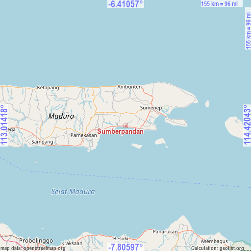
Sumberpandan GPS coordinates[2]
7° 6' 31.68" South, 113° 43' 2.28" East
| Map corner | latitude | longitude |
|---|---|---|
| Upper-left | -6.41057°, | 113.01418° |
| Center: | -7.1088°, | 113.7173° |
| Lower-right: | -7.80597°, | 114.42043° |
| Map W x H: | 155.2×155.2 km | = 96.4×96.4mi |
| max Lat: | 5.88969° ⇑40.3% North |
| Sumberpandan: | -7.1088° |
| min Lat: | ⇓59.7% South -10.934° |
| min Long | Sumberpandan | max Long |
| 95.1345° | 113.7173° | 140.9419° |
| W 64.6%⇐ | ⇒35.4% E |
Elevation
Elevation of Sumberpandan is 31 m = 102 ft, and this is 198.7 m = 652 ft below average elevation for this country.
| Max E: |
3185 m = 10449 ft | 70.7% |
| Avg. | 229.7 m = 754 ft | |
| Sumberpandan | 31 m = 102 ft | |
Min E: |
-1 m = -3 ft | 29.3% |
See also: Indonesia elevation on elevation.city.
Geographical zone
Sumberpandan is located in South Torrid zone (between Equator and Tropic of Capricorn). Distance of Equator is 790.4 km =491.1 mi to North.| Distance of | km | miles | from Sumberpandan |
|---|---|---|---|
| Equator | 790.4 | 491.1 | to North |
| Tropic Capricorn | 1815.5 | 1128.1 | to South |
| Antarctic Circle | 6610.7 | 4107.7 | to South |
| South Pole | 9216.6 | 5726.9 | to South |


Nearby cities:
15 places around Sumberpandan: (largest is in red/bold)
• Barru
2.1 km =1.3 mi,  318°
318°
• Batojaran
5.8 km =3.6 mi,  286°
286°
• Biyan
0.6 km =0.4 mi,  107°
107°
• Dajalorong
5.3 km =3.3 mi,  355°
355°
• Karangjati
6.3 km =3.9 mi,  4°
4°
• Kebunan
6.2 km =3.9 mi,  350°
350°
• Loaksongai
6.6 km =4.1 mi,  9°
9°
• Mrongi Daja
6.6 km =4.1 mi,  281°
281°
• Panggungdaja
6.7 km =4.2 mi,  336°
336°
• Pesisir
3.5 km =2.2 mi,  100°
100°
• Pragaan
6.3 km =3.9 mi,  267°
267°
• Sasar
3.5 km =2.2 mi,  32°
32°
• Solok
5.4 km =3.4 mi, 34°
• Solok Timur
6.4 km =4 mi, 31°
• Sumberkindagan
6.1 km =3.8 mi,  328°
328°
Sources, notices
• [Note1] Compared only with cities in Indonesia existing in our database
• [Src1] Map data: © OpenStreetMap contributors (CC-BY-SA)
• [Src2] Other city data from geonames.org with taken over terms of usage.
• [Src3] Geographical zone / Annual Mean Temperature by Robert A. Rohde @ Wikipedia
