Ta’anyar geodata
Ta’anyar (East Java) is a seat of a fourth-order administrative division; located in Indonesia in Asia/Jakarta (GMT+7) time zone. In our database, there are 407 cities with bigger population. Compared to other cities in Indonesia, 69.6% of cities are located further ↓South; 58.1% of cities are located further ←West and 95.5% of cities have higher elevation than Ta’anyar. Note1


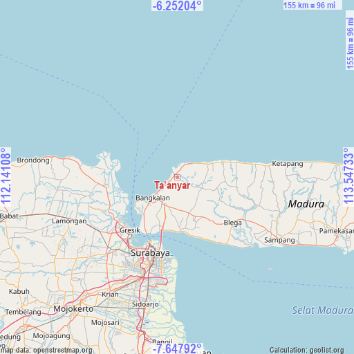
Ta’anyar GPS coordinates[2]
6° 57' 1.8" South, 112° 50' 39.12" East
| Map corner | latitude | longitude |
|---|---|---|
| Upper-left | -6.25204°, | 112.14108° |
| Center: | -6.9505°, | 112.8442° |
| Lower-right: | -7.64792°, | 113.54733° |
| Map W x H: | 155.2×155.2 km | = 96.4×96.4mi |
| max Lat: | 5.88969° ⇑30.4% North |
| Ta’anyar: | -6.9505° |
| min Lat: | ⇓69.6% South -10.934° |
| min Long | Ta’anyar | max Long |
| 95.1345° | 112.8442° | 140.9419° |
| W 58.1%⇐ | ⇒41.9% E |
Elevation
Elevation of Ta’anyar is 7 m = 23 ft, and this is 222.7 m = 731 ft below average elevation for this country.
| Max E: |
3185 m = 10449 ft | 95.5% |
| Avg. | 229.7 m = 754 ft | |
| Ta’anyar | 7 m = 23 ft | |
Min E: |
-1 m = -3 ft | 4.5% |
See also: Indonesia elevation on elevation.city.
Geographical zone
Ta’anyar is located in South Torrid zone (between Equator and Tropic of Capricorn). Distance of Equator is 772.8 km =480.2 mi to North.| Distance of | km | miles | from Ta’anyar |
|---|---|---|---|
| Equator | 772.8 | 480.2 | to North |
| Tropic Capricorn | 1833.1 | 1139 | to South |
| Antarctic Circle | 6628.4 | 4118.7 | to South |
| South Pole | 9234.2 | 5737.9 | to South |


Nearby cities:
15 places around Ta’anyar: (largest is in red/bold)
• Arosbaya
0.9 km =0.6 mi,  320°
320°
• Berbeluk Timur
2.6 km =1.6 mi,  121°
121°
• Cendagah
1.2 km =0.7 mi,  126°
126°
• Dlemer
1.4 km =0.9 mi,  167°
167°
• Karangasem Laok
2.7 km =1.7 mi,  52°
52°
• Karangpao
0.9 km =0.6 mi, 119°
• Lancang
1.8 km =1.1 mi,  262°
262°
• Lebak Timur
1.3 km =0.8 mi,  330°
330°
• Makamagung
0.9 km =0.6 mi,  151°
151°
• Makan
1.5 km =0.9 mi,  81°
81°
• Mangkon Daja
1.4 km =0.9 mi,  141°
141°
• Moarah Barat
1.7 km =1.1 mi,  346°
346°
• Polongan Daja
2.6 km =1.6 mi,  65°
65°
• Raas
2.5 km =1.6 mi,  4°
4°
• Tambeggan Satu
1.2 km =0.7 mi,  109°
109°
Sources, notices
• [Note1] Compared only with cities in Indonesia existing in our database
• [Src1] Map data: © OpenStreetMap contributors (CC-BY-SA)
• [Src2] Other city data from geonames.org with taken over terms of usage.
• [Src3] Geographical zone / Annual Mean Temperature by Robert A. Rohde @ Wikipedia
