Otan geodata
Otan (East Nusa Tenggara) is a seat of a fourth-order administrative division; located in Indonesia in Asia/Makassar (GMT+8) time zone. In our database, there are 407 cities with bigger population. Compared to other cities in Indonesia, 97.9% of cities are located further ↑North; 91.9% of cities are located further ←West and 95.5% of cities have higher elevation than Otan. Note1


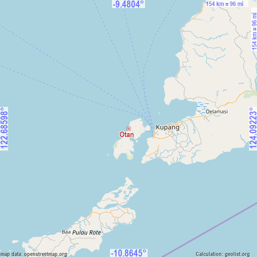
Otan GPS coordinates[2]
10° 10' 23.52" South, 123° 23' 20.76" East
| Map corner | latitude | longitude |
|---|---|---|
| Upper-left | -9.4804°, | 122.68598° |
| Center: | -10.1732°, | 123.3891° |
| Lower-right: | -10.8645°, | 124.09223° |
| Map W x H: | 153.9×153.9 km | = 95.6×95.6mi |
| max Lat: | 5.88969° ⇑97.9% North |
| Otan: | -10.1732° |
| min Lat: | ⇓2.1% South -10.934° |
| min Long | Otan | max Long |
| 95.1345° | 123.3891° | 140.9419° |
| W 91.9%⇐ | ⇒8.1% E |
Elevation
Elevation of Otan is 7 m = 23 ft, and this is 222.7 m = 731 ft below average elevation for this country.
| Max E: |
3185 m = 10449 ft | 95.5% |
| Avg. | 229.7 m = 754 ft | |
| Otan | 7 m = 23 ft | |
Min E: |
-1 m = -3 ft | 4.5% |
See also: Indonesia elevation on elevation.city.
Geographical zone
Otan is located in South Torrid zone (between Equator and Tropic of Capricorn). Distance of Equator is 1131.2 km =702.9 mi to North.| Distance of | km | miles | from Otan |
|---|---|---|---|
| Equator | 1131.2 | 702.9 | to North |
| Tropic Capricorn | 1474.8 | 916.4 | to South |
| Antarctic Circle | 6270 | 3896 | to South |
| South Pole | 8875.9 | 5515.2 | to South |


Nearby cities:
15 places around Otan: (largest is in red/bold)
• Alak
16 km =9.9 mi,  99°
99°
• Bolok
15.3 km =9.5 mi,  112°
112°
• Huilelot
6 km =3.7 mi, 107°
• Kaisalun
14.7 km =9.1 mi,  193°
193°
• Koblain
9.6 km =6 mi,  86°
86°
• Kuanfeu
16.2 km =10.1 mi, 111°
• Kuanheum
15.3 km =9.5 mi,  119°
119°
• Namosain
18.5 km =11.5 mi, 90°
• Nunbaundelha
19.8 km =12.3 mi, 89°
• Nunbaunsabu
19.4 km =12.1 mi, 89°
• Piaklain
4.3 km =2.7 mi, 187°
• Sepedale
12.9 km =8 mi,  177°
177°
• Uiasa
8.3 km =5.2 mi,  75°
75°
• Uitao
2.8 km =1.7 mi,  134°
134°
• Uitiuhtuan
14.5 km =9 mi,  212°
212°
Sources, notices
• [Note1] Compared only with cities in Indonesia existing in our database
• [Src1] Map data: © OpenStreetMap contributors (CC-BY-SA)
• [Src2] Other city data from geonames.org with taken over terms of usage.
• [Src3] Geographical zone / Annual Mean Temperature by Robert A. Rohde @ Wikipedia
