Merdeka geodata
Merdeka (East Nusa Tenggara) is a seat of a fourth-order administrative division; located in Indonesia in Asia/Makassar (GMT+8) time zone. In our database, there are 407 cities with bigger population. Compared to other cities in Indonesia, 97.7% of cities are located further ↑North; 92.9% of cities are located further ←West and 71.9% of cities have higher elevation than Merdeka. Note1


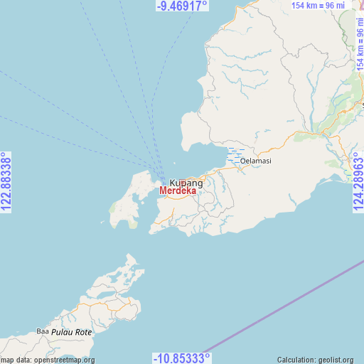
Merdeka GPS coordinates[2]
10° 9' 43.2" South, 123° 35' 11.4" East
| Map corner | latitude | longitude |
|---|---|---|
| Upper-left | -9.46917°, | 122.88338° |
| Center: | -10.162°, | 123.5865° |
| Lower-right: | -10.85333°, | 124.28963° |
| Map W x H: | 153.9×153.9 km | = 95.6×95.6mi |
| max Lat: | 5.88969° ⇑97.7% North |
| Merdeka: | -10.162° |
| min Lat: | ⇓2.3% South -10.934° |
| min Long | Merdeka | max Long |
| 95.1345° | 123.5865° | 140.9419° |
| W 92.9%⇐ | ⇒7.1% E |
Elevation
Elevation of Merdeka is 29 m = 95 ft, and this is 200.7 m = 658 ft below average elevation for this country.
| Max E: |
3185 m = 10449 ft | 71.9% |
| Avg. | 229.7 m = 754 ft | |
| Merdeka | 29 m = 95 ft | |
Min E: |
-1 m = -3 ft | 28.1% |
See also: Indonesia elevation on elevation.city.
Geographical zone
Merdeka is located in South Torrid zone (between Equator and Tropic of Capricorn). Distance of Equator is 1129.9 km =702.1 mi to North.| Distance of | km | miles | from Merdeka |
|---|---|---|---|
| Equator | 1129.9 | 702.1 | to North |
| Tropic Capricorn | 1476 | 917.1 | to South |
| Antarctic Circle | 6271.3 | 3896.8 | to South |
| South Pole | 8877.2 | 5516 | to South |


Nearby cities:
15 places around Merdeka: (largest is in red/bold)
• Airmata
1.1 km =0.7 mi,  243°
243°
• Bonipoi
0.7 km =0.4 mi,  273°
273°
• Fatufeto
1.3 km =0.8 mi,  262°
262°
• Fontein
0.7 km =0.4 mi,  225°
225°
• Kuanino
1.1 km =0.7 mi,  159°
159°
• Lai Lai Bisi Kopan
0.9 km =0.6 mi, 264°
• Mantasi
1.4 km =0.9 mi,  207°
207°
• Naikoten Dua
1.7 km =1.1 mi,  133°
133°
• Nunhila
1.8 km =1.1 mi,  249°
249°
• Oeba
0.6 km =0.4 mi,  63°
63°
• Oebobo
1.5 km =0.9 mi,  114°
114°
• Oetete
0.3 km =0.2 mi,  165°
165°
• Pasirpanjang
1.8 km =1.1 mi,  68°
68°
• Solor
0.5 km =0.3 mi,  283°
283°
• Todekisar
0.5 km =0.3 mi,  332°
332°
Sources, notices
• [Note1] Compared only with cities in Indonesia existing in our database
• [Src1] Map data: © OpenStreetMap contributors (CC-BY-SA)
• [Src2] Other city data from geonames.org with taken over terms of usage.
• [Src3] Geographical zone / Annual Mean Temperature by Robert A. Rohde @ Wikipedia
