Oeltua geodata
Oeltua (East Nusa Tenggara) is a seat of a fourth-order administrative division; located in Indonesia in Asia/Makassar (GMT+8) time zone. In our database, there are 407 cities with bigger population. Compared to other cities in Indonesia, 98.2% of cities are located further ↑North; 93.3% of cities are located further ←West and 71.6% of cities have lower elevation than Oeltua. Note1


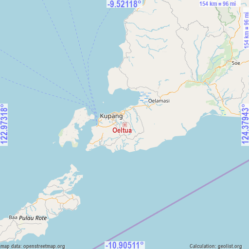
Oeltua GPS coordinates[2]
10° 12' 50.04" South, 123° 40' 34.68" East
| Map corner | latitude | longitude |
|---|---|---|
| Upper-left | -9.52118°, | 122.97318° |
| Center: | -10.2139°, | 123.6763° |
| Lower-right: | -10.90511°, | 124.37943° |
| Map W x H: | 153.9×153.9 km | = 95.6×95.6mi |
| max Lat: | 5.88969° ⇑98.2% North |
| Oeltua: | -10.2139° |
| min Lat: | ⇓1.8% South -10.934° |
| min Long | Oeltua | max Long |
| 95.1345° | 123.6763° | 140.9419° |
| W 93.3%⇐ | ⇒6.7% E |
Elevation
Elevation of Oeltua is 314 m = 1030 ft, and this is 84.3 m = 277 ft above average elevation for this country.
| Max E: |
3185 m = 10449 ft | 28.4% |
| Oeltua | 314 m 1030 ft | |
| Avg. | 229.7 m = 754 ft | |
Min E: |
-1 m = -3 ft | 71.6% |
See also: Indonesia elevation on elevation.city.
Geographical zone
Oeltua is located in South Torrid zone (between Equator and Tropic of Capricorn). Distance of Equator is 1135.7 km =705.7 mi to North.| Distance of | km | miles | from Oeltua |
|---|---|---|---|
| Equator | 1135.7 | 705.7 | to North |
| Tropic Capricorn | 1470.2 | 913.5 | to South |
| Antarctic Circle | 6265.5 | 3893.2 | to South |
| South Pole | 8871.4 | 5512.4 | to South |


Nearby cities:
15 places around Oeltua: (largest is in red/bold)
• Baumata
2.2 km =1.4 mi,  37°
37°
• Kiupakas
7 km =4.3 mi,  196°
196°
• Kolhua
3.7 km =2.3 mi,  270°
270°
• Kolomanu
3.9 km =2.4 mi,  140°
140°
• Liliba
6.2 km =3.9 mi,  316°
316°
• Maulafa
6.6 km =4.1 mi,  297°
297°
• Mekon
5.8 km =3.6 mi,  12°
12°
• Naimata
5.1 km =3.2 mi,  310°
310°
• Nonpuah
4.7 km =2.9 mi,  191°
191°
• Nunutba
5.4 km =3.4 mi,  264°
264°
• Oebufu
7.2 km =4.5 mi, 302°
• Oehani
4.1 km =2.5 mi,  118°
118°
• Penfui
4.6 km =2.9 mi,  334°
334°
• Tanenofunan
6.3 km =3.9 mi,  181°
181°
• Tualeu
4.4 km =2.7 mi,  210°
210°
Sources, notices
• [Note1] Compared only with cities in Indonesia existing in our database
• [Src1] Map data: © OpenStreetMap contributors (CC-BY-SA)
• [Src2] Other city data from geonames.org with taken over terms of usage.
• [Src3] Geographical zone / Annual Mean Temperature by Robert A. Rohde @ Wikipedia
