Huineno geodata
Huineno (East Nusa Tenggara) is a seat of a fourth-order administrative division; located in Indonesia in Asia/Makassar (GMT+8) time zone. In our database, there are 407 cities with bigger population. Compared to other cities in Indonesia, 95.1% of cities are located further ↑North; 94.9% of cities are located further ←West and 97.7% of cities have lower elevation than Huineno. Note1


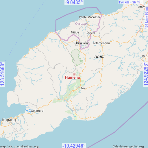
Huineno GPS coordinates[2]
9° 44' 13.92" South, 124° 13' 11.28" East
| Map corner | latitude | longitude |
|---|---|---|
| Upper-left | -9.0435°, | 123.51668° |
| Center: | -9.7372°, | 124.2198° |
| Lower-right: | -10.42946°, | 124.92293° |
| Map W x H: | 154.1×154.1 km | = 95.8×95.8mi |
| max Lat: | 5.88969° ⇑95.1% North |
| Huineno: | -9.7372° |
| min Lat: | ⇓4.9% South -10.934° |
| min Long | Huineno | max Long |
| 95.1345° | 124.2198° | 140.9419° |
| W 94.9%⇐ | ⇒5.1% E |
Elevation
Elevation of Huineno is 1009 m = 3310 ft, and this is 779.3 m = 2557 ft above average elevation for this country.
| Max E: |
3185 m = 10449 ft | 2.3% |
| Huineno | 1009 m 3310 ft | |
| Avg. | 229.7 m = 754 ft | |
Min E: |
-1 m = -3 ft | 97.7% |
See also: Indonesia elevation on elevation.city.
Geographical zone
Huineno is located in South Torrid zone (between Equator and Tropic of Capricorn). Distance of Equator is 1082.7 km =672.8 mi to North.| Distance of | km | miles | from Huineno |
|---|---|---|---|
| Equator | 1082.7 | 672.8 | to North |
| Tropic Capricorn | 1523.2 | 946.5 | to South |
| Antarctic Circle | 6318.5 | 3926.1 | to South |
| South Pole | 8924.4 | 5545.4 | to South |


Nearby cities:
15 places around Huineno: (largest is in red/bold)
• Beskolen
8.4 km =5.2 mi,  49°
49°
• Besnakeh
8.4 km =5.2 mi,  43°
43°
• Bosen
7.8 km =4.8 mi,  74°
74°
• Fatumnasi
9.6 km =6 mi,  1°
1°
• Kapan
5.9 km =3.7 mi,  87°
87°
• Lalin
6.4 km =4 mi, 89°
• Leloboko
6.8 km =4.2 mi,  329°
329°
• Nefokoko
7.4 km =4.6 mi,  280°
280°
• Nefonaek
8.5 km =5.3 mi,  101°
101°
• Numeto
7 km =4.3 mi,  118°
118°
• Obesi
6.3 km =3.9 mi,  79°
79°
• Oehala
6.9 km =4.3 mi,  26°
26°
• Oemollo
5.1 km =3.2 mi, 51°
• Sakteo
9.2 km =5.7 mi,  134°
134°
• Talmanu
4.5 km =2.8 mi, 97°
Sources, notices
• [Note1] Compared only with cities in Indonesia existing in our database
• [Src1] Map data: © OpenStreetMap contributors (CC-BY-SA)
• [Src2] Other city data from geonames.org with taken over terms of usage.
• [Src3] Geographical zone / Annual Mean Temperature by Robert A. Rohde @ Wikipedia
