Wonojati geodata
Wonojati (East Java) is a seat of a fourth-order administrative division; located in Indonesia in Asia/Jakarta (GMT+7) time zone. In our database, there are 407 cities with bigger population. Compared to other cities in Indonesia, 75.5% of cities are located further ↑North; 64% of cities are located further ←West and 60.8% of cities have higher elevation than Wonojati. Note1


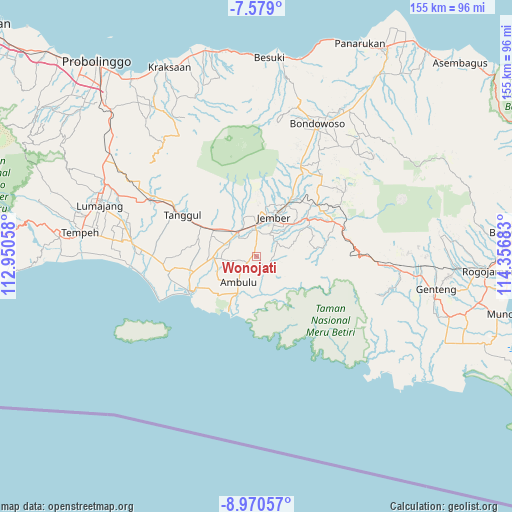
Wonojati GPS coordinates[2]
8° 16' 31.44" South, 113° 39' 13.32" East
| Map corner | latitude | longitude |
|---|---|---|
| Upper-left | -7.579°, | 112.95058° |
| Center: | -8.2754°, | 113.6537° |
| Lower-right: | -8.97057°, | 114.35683° |
| Map W x H: | 154.7×154.7 km | = 96.1×96.1mi |
| max Lat: | 5.88969° ⇑75.5% North |
| Wonojati: | -8.2754° |
| min Lat: | ⇓24.5% South -10.934° |
| min Long | Wonojati | max Long |
| 95.1345° | 113.6537° | 140.9419° |
| W 64%⇐ | ⇒36% E |
Elevation
Elevation of Wonojati is 56 m = 184 ft, and this is 173.7 m = 570 ft below average elevation for this country.
| Max E: |
3185 m = 10449 ft | 60.8% |
| Avg. | 229.7 m = 754 ft | |
| Wonojati | 56 m = 184 ft | |
Min E: |
-1 m = -3 ft | 39.2% |
See also: Indonesia elevation on elevation.city.
Geographical zone
Wonojati is located in South Torrid zone (between Equator and Tropic of Capricorn). Distance of Equator is 920.1 km =571.7 mi to North.| Distance of | km | miles | from Wonojati |
|---|---|---|---|
| Equator | 920.1 | 571.7 | to North |
| Tropic Capricorn | 1685.8 | 1047.5 | to South |
| Antarctic Circle | 6481 | 4027.1 | to South |
| South Pole | 9086.9 | 5646.3 | to South |


Nearby cities:
15 places around Wonojati: (largest is in red/bold)
• Ajung
7.7 km =4.8 mi,  1°
1°
• Durenan
3.5 km =2.2 mi,  359°
359°
• Gayasan Kulon
1.5 km =0.9 mi,  44°
44°
• Jatisari
5.2 km =3.2 mi,  203°
203°
• Jenggawah
1.2 km =0.7 mi,  328°
328°
• Karanganyarkrajan
6.8 km =4.2 mi,  222°
222°
• Kemuning
3.9 km =2.4 mi,  241°
241°
• Klompangan
4.6 km =2.9 mi, 0°
• Krajan Kertonegoro
5.6 km =3.5 mi,  229°
229°
• Krasak
6.1 km =3.8 mi, 2°
• Peji Satu
5.9 km =3.7 mi,  77°
77°
• Renes
7.3 km =4.5 mi,  46°
46°
• Sruni
3.1 km =1.9 mi, 215°
• Tamansari
7.7 km =4.8 mi,  94°
94°
• Tempurejo
3.9 km =2.4 mi,  133°
133°
Sources, notices
• [Note1] Compared only with cities in Indonesia existing in our database
• [Src1] Map data: © OpenStreetMap contributors (CC-BY-SA)
• [Src2] Other city data from geonames.org with taken over terms of usage.
• [Src3] Geographical zone / Annual Mean Temperature by Robert A. Rohde @ Wikipedia
