Liang geodata
Liang (West Nusa Tenggara) is a seat of a fourth-order administrative division; located in Indonesia in Asia/Makassar (GMT+8) time zone. In our database, there are 407 cities with bigger population. Compared to other cities in Indonesia, 92.2% of cities are located further ↑North; 78.1% of cities are located further ←West and 80.9% of cities have higher elevation than Liang. Note1


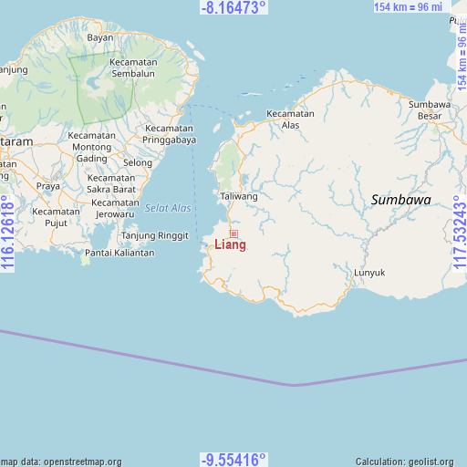
Liang GPS coordinates[2]
8° 51' 36.36" South, 116° 49' 45.48" East
| Map corner | latitude | longitude |
|---|---|---|
| Upper-left | -8.16473°, | 116.12618° |
| Center: | -8.8601°, | 116.8293° |
| Lower-right: | -9.55416°, | 117.53243° |
| Map W x H: | 154.5×154.5 km | = 96×96mi |
| max Lat: | 5.88969° ⇑92.2% North |
| Liang: | -8.8601° |
| min Lat: | ⇓7.8% South -10.934° |
| min Long | Liang | max Long |
| 95.1345° | 116.8293° | 140.9419° |
| W 78.1%⇐ | ⇒21.9% E |
Elevation
Elevation of Liang is 18 m = 59 ft, and this is 211.7 m = 695 ft below average elevation for this country.
| Max E: |
3185 m = 10449 ft | 80.9% |
| Avg. | 229.7 m = 754 ft | |
| Liang | 18 m = 59 ft | |
Min E: |
-1 m = -3 ft | 19.1% |
See also: Indonesia elevation on elevation.city.
Geographical zone
Liang is located in South Torrid zone (between Equator and Tropic of Capricorn). Distance of Equator is 985.2 km =612.2 mi to North.| Distance of | km | miles | from Liang |
|---|---|---|---|
| Equator | 985.2 | 612.2 | to North |
| Tropic Capricorn | 1620.8 | 1007.1 | to South |
| Antarctic Circle | 6416 | 3986.7 | to South |
| South Pole | 9021.9 | 5605.9 | to South |


Nearby cities:
15 places around Liang: (largest is in red/bold)
• Airsuning
23.4 km =14.5 mi,  6°
6°
• Besisora
0.3 km =0.2 mi,  324°
324°
• Bugis
13.2 km =8.2 mi, 6°
• Dalam
13.3 km =8.3 mi, 9°
• Labuhanlalar
5.3 km =3.3 mi,  343°
343°
• Menala
13.3 km =8.3 mi, 13°
• Meraran
19.2 km =11.9 mi, 6°
• Motong
13.2 km =8.2 mi, 11°
• Muraloka
11.2 km =7 mi,  29°
29°
• Rempe
24 km =14.9 mi, 9°
• Sampir
13.5 km =8.4 mi, 12°
• Sekongkang Bawah
14.7 km =9.1 mi,  216°
216°
• Seteluk Atas
26.2 km =16.3 mi, 9°
• Taliwang
13.1 km =8.1 mi, 11°
• Tepas
18.6 km =11.6 mi, 31°
Sources, notices
• [Note1] Compared only with cities in Indonesia existing in our database
• [Src1] Map data: © OpenStreetMap contributors (CC-BY-SA)
• [Src2] Other city data from geonames.org with taken over terms of usage.
• [Src3] Geographical zone / Annual Mean Temperature by Robert A. Rohde @ Wikipedia
