Trenggalek geodata
Trenggalek (East Java) is a seat of a second-order administrative division; located in Indonesia in Asia/Jakarta (GMT+7) time zone. With population of 29,083 people, there are 321 cities with bigger population in this country. Compared to other cities in Indonesia, 64.5% of cities are located further ↑North; 54.4% of cities are located further →East and 52.7% of cities have lower elevation than Trenggalek. Note1


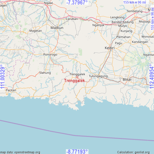
Trenggalek GPS coordinates[2]
8° 4' 35.04" South, 111° 42' 23.076" East
| Map corner | latitude | longitude |
|---|---|---|
| Upper-left | -7.37967°, | 111.00329° |
| Center: | -8.0764°, | 111.70641° |
| Lower-right: | -8.77193°, | 112.40954° |
| Map W x H: | 154.8×154.8 km | = 96.2×96.2mi |
| max Lat: | 5.88969° ⇑64.5% North |
| Trenggalek: | -8.0764° |
| min Lat: | ⇓35.5% South -10.934° |
| min Long | Trenggalek | max Long |
| 95.1345° | 111.70641° | 140.9419° |
| W 45.6%⇐ | ⇒54.4% E |
Elevation
Elevation of Trenggalek is 113 m = 371 ft, and this is 116.7 m = 383 ft below average elevation for this country.
| Max E: |
3185 m = 10449 ft | 47.3% |
| Avg. | 229.7 m = 754 ft | |
| Trenggalek | 113 m = 371 ft | |
Min E: |
-1 m = -3 ft | 52.7% |
See also: Indonesia elevation on elevation.city.
Geographical zone
Trenggalek is located in South Torrid zone (between Equator and Tropic of Capricorn). Distance of Equator is 898 km =558 mi to North.| Distance of | km | miles | from Trenggalek |
|---|---|---|---|
| Equator | 898 | 558 | to North |
| Tropic Capricorn | 1707.9 | 1061.2 | to South |
| Antarctic Circle | 6503.2 | 4040.9 | to South |
| South Pole | 9109.1 | 5660.1 | to South |


Nearby cities:
15 places around Trenggalek: (largest is in red/bold)
• Banjar
3.1 km =1.9 mi,  266°
266°
• Duwet
3.7 km =2.3 mi,  125°
125°
• Jatiprahu
2.7 km =1.7 mi,  217°
217°
• Kelutan
1.1 km =0.7 mi,  344°
344°
• Manggis
3.8 km =2.4 mi,  172°
172°
• Ngantrukrajan
2.4 km =1.5 mi,  356°
356°
• Ngepoh
1.4 km =0.9 mi,  96°
96°
• Rejosari
3.5 km =2.2 mi,  278°
278°
• Sokobanteng
0.5 km =0.3 mi,  154°
154°
• Sumbergedong
2.7 km =1.7 mi,  3°
3°
• Sumberkrajan
3.5 km =2.2 mi,  324°
324°
• Surodakan
3.3 km =2.1 mi,  20°
20°
• Tamanan
2 km =1.2 mi,  346°
346°
• Wadi Kidul
4 km =2.5 mi,  90°
90°
• Wonocoyo
3.3 km =2.1 mi, 149°
Sources, notices
• [Note1] Compared only with cities in Indonesia existing in our database
• [Src1] Map data: © OpenStreetMap contributors (CC-BY-SA)
• [Src2] Other city data from geonames.org with taken over terms of usage.
• [Src3] Geographical zone / Annual Mean Temperature by Robert A. Rohde @ Wikipedia
