Segong geodata
Segong (West Java) is a seat of a fourth-order administrative division; located in Indonesia in Asia/Jakarta (GMT+7) time zone. In our database, there are 407 cities with bigger population. Compared to other cities in Indonesia, 60.8% of cities are located further ↓South; 69.5% of cities are located further →East and 65.9% of cities have lower elevation than Segong. Note1


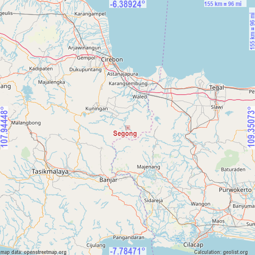
Segong GPS coordinates[2]
7° 5' 15" South, 108° 38' 51.36" East
| Map corner | latitude | longitude |
|---|---|---|
| Upper-left | -6.38924°, | 107.94448° |
| Center: | -7.0875°, | 108.6476° |
| Lower-right: | -7.78471°, | 109.35073° |
| Map W x H: | 155.2×155.2 km | = 96.4×96.4mi |
| max Lat: | 5.88969° ⇑39.2% North |
| Segong: | -7.0875° |
| min Lat: | ⇓60.8% South -10.934° |
| min Long | Segong | max Long |
| 95.1345° | 108.6476° | 140.9419° |
| W 30.5%⇐ | ⇒69.5% E |
Elevation
Elevation of Segong is 236 m = 774 ft, and this is 6.3 m = 21 ft above average elevation for this country.
| Max E: |
3185 m = 10449 ft | 34.1% |
| Segong | 236 m 774 ft | |
| Avg. | 229.7 m = 754 ft | |
Min E: |
-1 m = -3 ft | 65.9% |
See also: Indonesia elevation on elevation.city.
Geographical zone
Segong is located in South Torrid zone (between Equator and Tropic of Capricorn). Distance of Equator is 788.1 km =489.7 mi to North.| Distance of | km | miles | from Segong |
|---|---|---|---|
| Equator | 788.1 | 489.7 | to North |
| Tropic Capricorn | 1817.9 | 1129.6 | to South |
| Antarctic Circle | 6613.1 | 4109.2 | to South |
| South Pole | 9219 | 5728.4 | to South |


Nearby cities:
15 places around Segong: (largest is in red/bold)
• Cilayung
2.9 km =1.8 mi,  277°
277°
• Citundun
3.9 km =2.4 mi,  228°
228°
• Ciwaru
2.4 km =1.5 mi,  296°
296°
• Dukuhpicung
5.3 km =3.3 mi,  336°
336°
• Garajati
4.3 km =2.7 mi,  345°
345°
• Girang
5.4 km =3.4 mi,  266°
266°
• Jabranti
4.9 km =3 mi,  136°
136°
• Kaduagung
1.7 km =1.1 mi, 142°
• Karanganyar
4 km =2.5 mi,  243°
243°
• Karangbaru
3.5 km =2.2 mi, 341°
• Karangkancana
1.3 km =0.8 mi,  124°
124°
• Margacina
2.6 km =1.6 mi,  186°
186°
• Sagara
2.8 km =1.7 mi,  197°
197°
• Sukagalih
4.6 km =2.9 mi,  51°
51°
• Tanjungkerta
3.7 km =2.3 mi,  59°
59°
Sources, notices
• [Note1] Compared only with cities in Indonesia existing in our database
• [Src1] Map data: © OpenStreetMap contributors (CC-BY-SA)
• [Src2] Other city data from geonames.org with taken over terms of usage.
• [Src3] Geographical zone / Annual Mean Temperature by Robert A. Rohde @ Wikipedia
