Paseh geodata
Paseh (West Java) is a populated place; located in Indonesia in Asia/Jakarta (GMT+7) time zone. With population of 126,181 people, there are 100 cities with bigger population in this country. Compared to other cities in Indonesia, 60% of cities are located further ↓South; 83.2% of cities are located further →East and 96.6% of cities have lower elevation than Paseh. Note1


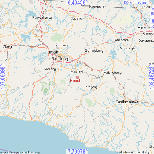
Paseh GPS coordinates[2]
7° 6' 9.36" South, 107° 45' 50.76" East
| Map corner | latitude | longitude |
|---|---|---|
| Upper-left | -6.40436°, | 107.06098° |
| Center: | -7.1026°, | 107.7641° |
| Lower-right: | -7.79978°, | 108.46723° |
| Map W x H: | 155.2×155.2 km | = 96.4×96.4mi |
| max Lat: | 5.88969° ⇑40% North |
| Paseh: | -7.1026° |
| min Lat: | ⇓60% South -10.934° |
| min Long | Paseh | max Long |
| 95.1345° | 107.7641° | 140.9419° |
| W 16.8%⇐ | ⇒83.2% E |
Elevation
Elevation of Paseh is 918 m = 3012 ft, and this is 688.3 m = 2258 ft above average elevation for this country.
| Max E: |
3185 m = 10449 ft | 3.4% |
| Paseh | 918 m 3012 ft | |
| Avg. | 229.7 m = 754 ft | |
Min E: |
-1 m = -3 ft | 96.6% |
See also: Paseh elevation on elevation.city.
Geographical zone
Paseh is located in South Torrid zone (between Equator and Tropic of Capricorn). Distance of Equator is 789.7 km =490.7 mi to North.| Distance of | km | miles | from Paseh |
|---|---|---|---|
| Equator | 789.7 | 490.7 | to North |
| Tropic Capricorn | 1816.2 | 1128.5 | to South |
| Antarctic Circle | 6611.4 | 4108.1 | to South |
| South Pole | 9217.3 | 5727.4 | to South |


Nearby cities:
15 places around Paseh: (largest is in red/bold)
• Ciharus
12.5 km =7.8 mi,  87°
87°
• Cihuni
15.4 km =9.6 mi,  76°
76°
• Cipancar
13.9 km =8.6 mi, 90°
• Cipeundeuy
14.3 km =8.9 mi, 78°
• Halteu
15 km =9.3 mi, 81°
• Hegarsari
13.6 km =8.5 mi, 83°
• Karangtengah
14.5 km =9 mi, 77°
• Leles
14.9 km =9.3 mi, 93°
• Maribaya
12.5 km =7.8 mi, 81°
• Nangkasari
13.1 km =8.1 mi, 87°
• Pasar Kulon
14.7 km =9.1 mi, 93°
• Pasirsalam
14.6 km =9.1 mi,  97°
97°
• Salamnunggal
14.8 km =9.2 mi, 91°
• Slamanyah
14.7 km =9.1 mi, 84°
• Sukasari
14.7 km =9.1 mi, 78°
Sources, notices
• [Note1] Compared only with cities in Indonesia existing in our database
• [Src1] Map data: © OpenStreetMap contributors (CC-BY-SA)
• [Src2] Other city data from geonames.org with taken over terms of usage.
• [Src3] Geographical zone / Annual Mean Temperature by Robert A. Rohde @ Wikipedia
