Kedunglo geodata
Kedunglo (East Java) is a seat of a fourth-order administrative division; located in Indonesia in Asia/Jakarta (GMT+7) time zone. In our database, there are 407 cities with bigger population. Compared to other cities in Indonesia, 60.8% of cities are located further ↑North; 68.5% of cities are located further ←West and 54.8% of cities have higher elevation than Kedunglo. Note1


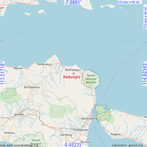
Kedunglo GPS coordinates[2]
7° 47' 10.68" South, 114° 13' 13.08" East
| Map corner | latitude | longitude |
|---|---|---|
| Upper-left | -7.0891°, | 113.51718° |
| Center: | -7.7863°, | 114.2203° |
| Lower-right: | -8.48235°, | 114.92343° |
| Map W x H: | 154.9×154.9 km | = 96.3×96.3mi |
| max Lat: | 5.88969° ⇑60.8% North |
| Kedunglo: | -7.7863° |
| min Lat: | ⇓39.2% South -10.934° |
| min Long | Kedunglo | max Long |
| 95.1345° | 114.2203° | 140.9419° |
| W 68.5%⇐ | ⇒31.5% E |
Elevation
Elevation of Kedunglo is 86 m = 282 ft, and this is 143.7 m = 471 ft below average elevation for this country.
| Max E: |
3185 m = 10449 ft | 54.8% |
| Avg. | 229.7 m = 754 ft | |
| Kedunglo | 86 m = 282 ft | |
Min E: |
-1 m = -3 ft | 45.2% |
See also: Indonesia elevation on elevation.city.
Geographical zone
Kedunglo is located in South Torrid zone (between Equator and Tropic of Capricorn). Distance of Equator is 865.8 km =538 mi to North.| Distance of | km | miles | from Kedunglo |
|---|---|---|---|
| Equator | 865.8 | 538 | to North |
| Tropic Capricorn | 1740.2 | 1081.3 | to South |
| Antarctic Circle | 6535.4 | 4060.9 | to South |
| South Pole | 9141.3 | 5680.1 | to South |


Nearby cities:
15 places around Kedunglo: (largest is in red/bold)
• Asembagus
4.1 km =2.5 mi,  344°
344°
• Awar-awar
2.9 km =1.8 mi,  9°
9°
• Bantal
1.3 km =0.8 mi,  112°
112°
• Cungapmimbo
7.5 km =4.7 mi,  84°
84°
• Curahkalak Tengah
5.6 km =3.5 mi,  313°
313°
• Kedungdowo
8.7 km =5.4 mi,  296°
296°
• Kertosari
4.1 km =2.5 mi,  331°
331°
• Ketowan
9.8 km =6.1 mi,  272°
272°
• Mojosari
3.8 km =2.4 mi, 312°
• Pariyaan
5.2 km =3.2 mi,  286°
286°
• Perante Tengah
3.1 km =1.9 mi,  358°
358°
• Perante Utara
3.5 km =2.2 mi,  353°
353°
• Randuagung
2.9 km =1.8 mi,  37°
37°
• Sumberanyar
8.8 km =5.5 mi,  87°
87°
• Trigonco Tengah
3.9 km =2.4 mi, 355°
Sources, notices
• [Note1] Compared only with cities in Indonesia existing in our database
• [Src1] Map data: © OpenStreetMap contributors (CC-BY-SA)
• [Src2] Other city data from geonames.org with taken over terms of usage.
• [Src3] Geographical zone / Annual Mean Temperature by Robert A. Rohde @ Wikipedia
