Bungkal geodata
Bungkal (East Java) is a seat of a third-order administrative division; located in Indonesia in Asia/Jakarta (GMT+7) time zone. In our database, there are 407 cities with bigger population. Compared to other cities in Indonesia, 61.6% of cities are located further ↑North; 59% of cities are located further →East and 56.2% of cities have lower elevation than Bungkal. Note1


Bungkal GPS coordinates[2]
8° 0' 28.44" South, 111° 27' 14.76" East
| Map corner | latitude | longitude |
|---|---|---|
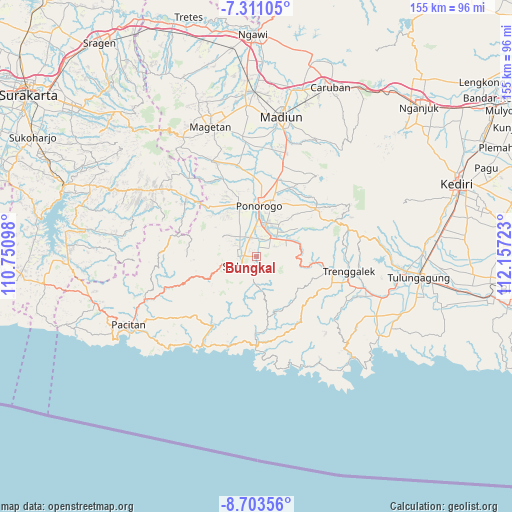
| Upper-left | -7.31105°, | 110.75098° |
| Center: | -8.0079°, | 111.4541° |
| Lower-right: | -8.70356°, | 112.15723° |
| Map W x H: | 154.8×154.8 km | = 96.2×96.2mi |
| max Lat: | 5.88969° ⇑61.6% North |
| Bungkal: | -8.0079° |
| min Lat: | ⇓38.4% South -10.934° |
| min Long | Bungkal | max Long |
| 95.1345° | 111.4541° | 140.9419° |
| W 41%⇐ | ⇒59% E |
Elevation
Elevation of Bungkal is 131 m = 430 ft, and this is 98.7 m = 324 ft below average elevation for this country.
| Max E: |
3185 m = 10449 ft | 43.8% |
| Avg. | 229.7 m = 754 ft | |
| Bungkal | 131 m = 430 ft | |
Min E: |
-1 m = -3 ft | 56.2% |
See also: Indonesia elevation on elevation.city.
Geographical zone
Bungkal is located in South Torrid zone (between Equator and Tropic of Capricorn). Distance of Equator is 890.4 km =553.3 mi to North.| Distance of | km | miles | from Bungkal |
|---|---|---|---|
| Equator | 890.4 | 553.3 | to North |
| Tropic Capricorn | 1715.5 | 1066 | to South |
| Antarctic Circle | 6510.8 | 4045.6 | to South |
| South Pole | 9116.7 | 5664.9 | to South |


Nearby cities:
15 places around Bungkal: (largest is in red/bold)
• Banggel
3.6 km =2.2 mi,  281°
281°
• Beluk
0.9 km =0.6 mi,  296°
296°
• Bibis
1.4 km =0.9 mi,  93°
93°
• Bugis
1.7 km =1.1 mi,  219°
219°
• Gabahan
1.2 km =0.7 mi,  188°
188°
• Klatakan
0.9 km =0.6 mi,  82°
82°
• Krajan Menggare
4.2 km =2.6 mi,  260°
260°
• Kudo
0.3 km =0.2 mi,  324°
324°
• Maron
3.6 km =2.2 mi,  273°
273°
• Melikan
4.4 km =2.7 mi, 272°
• Munung
2.6 km =1.6 mi,  158°
158°
• Nambak Tengah
0.9 km =0.6 mi, 261°
• Pelem Satu
4 km =2.5 mi,  173°
173°
• Setono
2.4 km =1.5 mi, 268°
• Tiron
2.5 km =1.6 mi,  181°
181°
Sources, notices
• [Note1] Compared only with cities in Indonesia existing in our database
• [Src1] Map data: © OpenStreetMap contributors (CC-BY-SA)
• [Src2] Other city data from geonames.org with taken over terms of usage.
• [Src3] Geographical zone / Annual Mean Temperature by Robert A. Rohde @ Wikipedia
