‘En Gedi geodata
‘En Gedi (Southern District) is a populated place; located in Israel in Asia/Jerusalem (GMT+3) time zone. With population of 603 people, there are 166 cities with bigger population in this country. Compared to other cities in Israel, 92.9% of cities are located further ↑North; 89.3% of cities are located further ←West and 99.4% of cities have higher elevation than ‘En Gedi. Note1


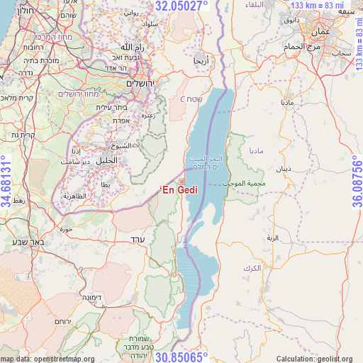
‘En Gedi GPS coordinates[2]
31° 27' 8.568" North, 35° 23' 3.948" East
| Map corner | latitude | longitude |
|---|---|---|
| Upper-left | 32.05027°, | 34.68131° |
| Center: | 31.45238°, | 35.38443° |
| Lower-right: | 30.85065°, | 36.08756° |
| Map W x H: | 133.4×133.4 km | = 82.9×82.9mi |
| max Lat: | 33.27918° ⇑92.9% North |
| ‘En Gedi: | 31.45238° |
| min Lat: | ⇓7.1% South 29.55805° |
| min Long | ‘En Gedi | max Long |
| 34.57149° | 35.38443° | 35.81084° |
| W 89.3%⇐ | ⇒10.7% E |
Elevation
Elevation of ‘En Gedi is -285 m = -935 ft, and this is 508.4 m = 1668 ft below average elevation for this country.
| Max E: |
988 m = 3241 ft | 99.4% |
| Avg. | 223.4 m = 733 ft | |
| ‘En Gedi | -285 m = -935 ft | |
Min E: |
-380 m = -1247 ft | 0.6% |
See also: Israel elevation on elevation.city.
Geographical zone
‘En Gedi is located in North temperate zone (between Tropic of Cancer and the Arctic Circle). Distance of this Northern Tropic circle is 891.3 km =553.8 mi to South.| Distance of | km | miles | from ‘En Gedi |
|---|---|---|---|
| North Pole | 6509.9 | 4045.1 | to North |
| Arctic Circle | 3904 | 2425.8 | to North |
| Tropic Cancer | 891.3 | 553.8 | to South |
| Equator | 3497.2 | 2173.1 | to South |


Nearby cities:
15 places around ‘En Gedi: (largest is in red/bold)
• Abū Ghaush
47.2 km =29.3 mi,  326°
326°
• Arad
27 km =16.8 mi,  217°
217°
• Beit Horon
52.9 km =32.9 mi, 332°
• Bet Shemesh
48.3 km =30 mi,  309°
309°
• Dimona
54 km =33.6 mi, 218°
• Even Sappir
41.9 km =26 mi, 325°
• Giv'on HaHadasha
48.9 km =30.4 mi, 334°
• Har Adar
48.1 km =29.9 mi, 330°
• Jerusalem
38.6 km =24 mi,  335°
335°
• Mevasseret Ẕiyyon
44.7 km =27.8 mi, 330°
• Mevo Betar
39.9 km =24.8 mi,  318°
318°
• Tzova
44.6 km =27.7 mi, 325°
• West Jerusalem
39.8 km =24.7 mi, 336°
• Ẕur Hadassa
40.3 km =25 mi, 317°
• ‘En Boqeq
28.2 km =17.5 mi,  184°
184°
Sources, notices
• [Note1] Compared only with cities in Israel existing in our database
• [Src1] Map data: © OpenStreetMap contributors (CC-BY-SA)
• [Src2] Other city data from geonames.org with taken over terms of usage.
• [Src3] Geographical zone / Annual Mean Temperature by Robert A. Rohde @ Wikipedia
