Onchan geodata
Onchan is a seat of a first-order administrative division; located in Isle of Man in Europe/Isle_of_Man (GMT+1) time zone. In our database, there are 6 cities with bigger population. Compared to other cities in Isle of Man, 60% of cities are located further ↑North; 70% of cities are located further ←West and 80% of cities have lower elevation than Onchan. Note1


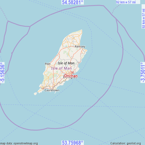
Onchan GPS coordinates[2]
54° 10' 23.844" North, 4° 27' 11.664" West
| Map corner | latitude | longitude |
|---|---|---|
| Upper-left | 54.58281°, | -5.15636° |
| Center: | 54.17329°, | -4.45324° |
| Lower-right: | 53.75968°, | -3.75011° |
| Map W x H: | 91.5×91.5 km | = 56.9×56.9mi |
| max Lat: | 54.38256° ⇑60% North |
| Onchan: | 54.17329° |
| min Lat: | ⇓40% South 54.07405° |
| min Long | Onchan | max Long |
| -4.75099° | -4.45324° | -4.31844° |
| W 70%⇐ | ⇒30% E |
Elevation
Elevation of Onchan is 58 m = 190 ft, and this is 17.7 m = 58 ft above average elevation for this country.
| Max E: |
137 m = 449 ft | 20% |
| Onchan | 58 m 190 ft | |
| Avg. | 40.3 m = 132 ft | |
Min E: |
7 m = 23 ft | 80% |
See also: Isle of Man elevation on elevation.city.
Geographical zone
Onchan is located in North temperate zone (between Tropic of Cancer and the Arctic Circle). Distance of this North polar circle is 1377.7 km =856.1 mi to North.| Distance of | km | miles | from Onchan |
|---|---|---|---|
| North Pole | 3983.6 | 2475.3 | to North |
| Arctic Circle | 1377.7 | 856.1 | to North |
| Tropic Cancer | 3417.6 | 2123.6 | to South |
| Equator | 6023.5 | 3742.8 | to South |


Nearby cities:
15 places around Onchan: (largest is in red/bold)
• Ballabeg
17.1 km =10.6 mi,  241°
241°
• Ballasalla
14.4 km =8.9 mi,  233°
233°
• Ballaugh
16.5 km =10.3 mi,  338°
338°
• Castletown
17.1 km =10.6 mi, 229°
• Crosby
7.5 km =4.7 mi,  278°
278°
• Douglas
3.2 km =2 mi,  217°
217°
• Kirk Braddan
4.2 km =2.6 mi,  259°
259°
• Kirkmichael
15.2 km =9.4 mi,  325°
325°
• Laxey
7.2 km =4.5 mi,  28°
28°
• Lezayre
16.1 km =10 mi,  8°
8°
• Maughold
16.5 km =10.3 mi, 32°
• Patrick
16.1 km =10 mi, 282°
• Peel
16.4 km =10.2 mi,  289°
289°
• Ramsey
17.2 km =10.7 mi, 14°
• Santon
10.6 km =6.6 mi, 233°
Sources, notices
• [Note1] Compared only with cities in Isle of Man existing in our database
• [Src1] Map data: © OpenStreetMap contributors (CC-BY-SA)
• [Src2] Other city data from geonames.org with taken over terms of usage.
• [Src3] Geographical zone / Annual Mean Temperature by Robert A. Rohde @ Wikipedia
