Uran geodata
Uran (Maharashtra) is a populated place; located in India in Asia/Kolkata (GMT+5.5) time zone. With population of 25,598 people, there are 1661 cities with bigger population in this country. Compared to other cities in India, 68.9% of cities are located further ↑North; 95.2% of cities are located further →East and 99% of cities have higher elevation than Uran. Note1


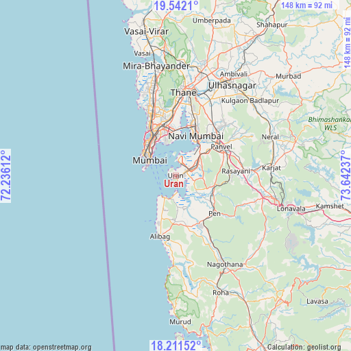
Uran GPS coordinates[2]
18° 52' 41.268" North, 72° 56' 21.264" East
| Map corner | latitude | longitude |
|---|---|---|
| Upper-left | 19.5421°, | 72.23612° |
| Center: | 18.87813°, | 72.93924° |
| Lower-right: | 18.21152°, | 73.64237° |
| Map W x H: | 147.9×147.9 km | = 91.9×91.9mi |
| max Lat: | 34.9274° ⇑68.9% North |
| Uran: | 18.87813° |
| min Lat: | ⇓31.1% South 8.09008° |
| min Long | Uran | max Long |
| 68.82655° | 72.93924° | 96.81° |
| W 4.8%⇐ | ⇒95.2% E |
Elevation
Elevation of Uran is 7 m = 23 ft, and this is 288.6 m = 947 ft below average elevation for this country.
| Max E: |
3681 m = 12077 ft | 99% |
| Avg. | 295.6 m = 970 ft | |
| Uran | 7 m = 23 ft | |
Min E: |
1 m = 3 ft | 1% |
See also: India elevation on elevation.city.
Geographical zone
Uran is located in North Torrid zone (between Equator and Tropic of Cancer). Distance of this Northern Tropic circle is 506.9 km =315 mi to North.| Distance of | km | miles | from Uran |
|---|---|---|---|
| North Pole | 7908 | 4913.8 | to North |
| Arctic Circle | 5302.1 | 3294.6 | to North |
| Tropic Cancer | 506.9 | 315 | to North |
| Equator | 2099.1 | 1304.3 | to South |


Nearby cities:
15 places around Uran: (largest is in red/bold)
• Airoli
30.9 km =19.2 mi,  11°
11°
• Alībāg
26.4 km =16.4 mi,  194°
194°
• Artist Village
20.3 km =12.6 mi,  32°
32°
• Borivli
40.5 km =25.2 mi,  348°
348°
• Dombivli
40.6 km =25.2 mi,  21°
21°
• Karjat
40.6 km =25.2 mi,  84°
84°
• Kālundri
22.8 km =14.2 mi,  60°
60°
• Mumbai
22.5 km =14 mi,  344°
344°
• Mātherān
36.2 km =22.5 mi,  71°
71°
• Navi Mumbai
19.4 km =12.1 mi, 24°
• Panvel
21.8 km =13.5 mi, 55°
• Pen
22.7 km =14.1 mi,  133°
133°
• Powai
26.7 km =16.6 mi, 352°
• Revadanda
36.1 km =22.4 mi,  182°
182°
• Thāne
35.6 km =22.1 mi,  4°
4°
Sources, notices
• [Note1] Compared only with cities in India existing in our database
• [Src1] Map data: © OpenStreetMap contributors (CC-BY-SA)
• [Src2] Other city data from geonames.org with taken over terms of usage.
• [Src3] Geographical zone / Annual Mean Temperature by Robert A. Rohde @ Wikipedia
