Pujali geodata
Pujali (West Bengal) is a populated place; located in India in Asia/Kolkata (GMT+5.5) time zone. With population of 45,379 people, there are 975 cities with bigger population in this country. Compared to other cities in India, 53.3% of cities are located further ↑North; 91.5% of cities are located further ←West and 94.3% of cities have higher elevation than Pujali. Note1


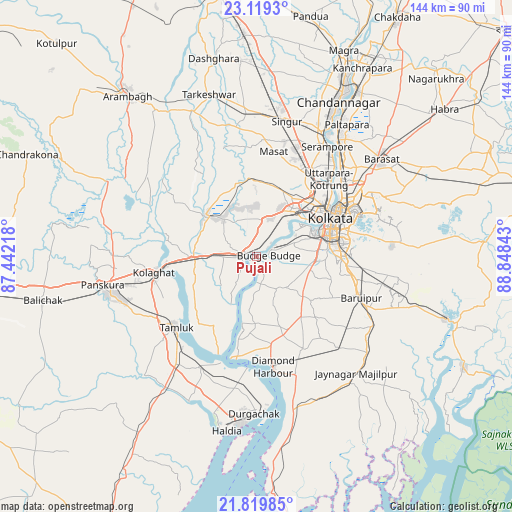
Pujali GPS coordinates[2]
22° 28' 15.96" North, 88° 8' 43.08" East
| Map corner | latitude | longitude |
|---|---|---|
| Upper-left | 23.1193°, | 87.44218° |
| Center: | 22.4711°, | 88.1453° |
| Lower-right: | 21.81985°, | 88.84843° |
| Map W x H: | 144.5×144.5 km | = 89.8×89.8mi |
| max Lat: | 34.9274° ⇑53.3% North |
| Pujali: | 22.4711° |
| min Lat: | ⇓46.7% South 8.09008° |
| min Long | Pujali | max Long |
| 68.82655° | 88.1453° | 96.81° |
| W 91.5%⇐ | ⇒8.5% E |
Elevation
Elevation of Pujali is 12 m = 39 ft, and this is 283.6 m = 930 ft below average elevation for this country.
| Max E: |
3681 m = 12077 ft | 94.3% |
| Avg. | 295.6 m = 970 ft | |
| Pujali | 12 m = 39 ft | |
Min E: |
1 m = 3 ft | 5.7% |
See also: Pujali elevation on elevation.city.
Geographical zone
Pujali is located in North Torrid zone (between Equator and Tropic of Cancer). Distance of this Northern Tropic circle is 107.4 km =66.7 mi to North.| Distance of | km | miles | from Pujali |
|---|---|---|---|
| North Pole | 7508.5 | 4665.6 | to North |
| Arctic Circle | 4902.6 | 3046.3 | to North |
| Tropic Cancer | 107.4 | 66.7 | to North |
| Equator | 2498.6 | 1552.6 | to South |


Nearby cities:
15 places around Pujali: (largest is in red/bold)
• Baj Baj
3.4 km =2.1 mi,  82°
82°
• Bhandārdaha
16.7 km =10.4 mi,  16°
16°
• Bishnupur
16.8 km =10.4 mi,  128°
128°
• Bāwāli
7.1 km =4.4 mi,  135°
135°
• Dhulagari
12.6 km =7.8 mi,  12°
12°
• Fort Gloster
5.4 km =3.4 mi,  46°
46°
• Gobindapur
14.6 km =9.1 mi,  337°
337°
• Mahiari
16 km =9.9 mi,  35°
35°
• Masila
15.2 km =9.4 mi, 36°
• Nangi
8.3 km =5.2 mi,  60°
60°
• Pānchla
7.3 km =4.5 mi,  354°
354°
• Raghudebbati
8 km =5 mi, 40°
• Santoshpur
13.9 km =8.6 mi,  66°
66°
• Sāhāpur
6.3 km =3.9 mi, 20°
• Sānkrāil
12 km =7.5 mi, 43°
Sources, notices
• [Note1] Compared only with cities in India existing in our database
• [Src1] Map data: © OpenStreetMap contributors (CC-BY-SA)
• [Src2] Other city data from geonames.org with taken over terms of usage.
• [Src3] Geographical zone / Annual Mean Temperature by Robert A. Rohde @ Wikipedia
