Trenta geodata
Trenta (Calabria) is a seat of a third-order administrative division; located in Italy in Europe/Rome (GMT+2) time zone. With population of 900 people, there are 7152 cities with bigger population in this country. Compared to other cities in Italy, 91.4% of cities are located further ↑North; 95.4% of cities are located further ←West and 84.8% of cities have lower elevation than Trenta. Note1
Administrative division(s):
- Level 1: Calabria
- Level 2: Provincia di Cosenza
- Level 3: Casali del Manco


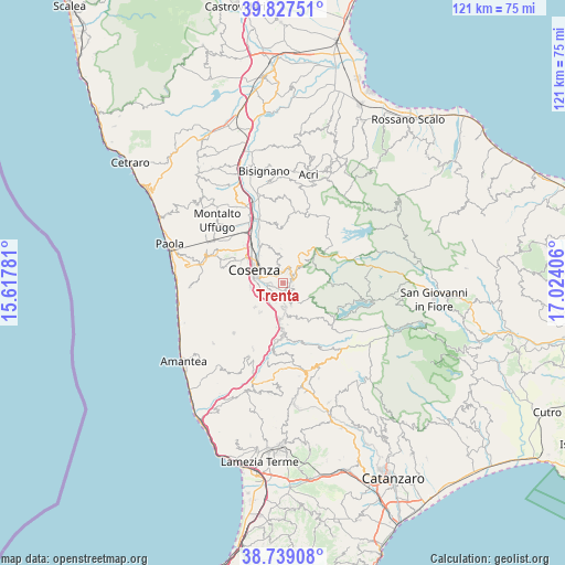
Trenta GPS coordinates[2]
39° 17' 7.476" North, 16° 19' 15.348" East
| Map corner | latitude | longitude |
|---|---|---|
| Upper-left | 39.82751°, | 15.61781° |
| Center: | 39.28541°, | 16.32093° |
| Lower-right: | 38.73908°, | 17.02406° |
| Map W x H: | 121×121 km | = 75.2×75.2mi |
| max Lat: | 47.04031° ⇑91.4% North |
| Trenta: | 39.28541° |
| min Lat: | ⇓8.6% South 35.50142° |
| min Long | Trenta | max Long |
| 6.69888° | 16.32093° | 18.48682° |
| W 95.4%⇐ | ⇒4.6% E |
Elevation
Elevation of Trenta is 607 m = 1991 ft, and this is 300.3 m = 985 ft above average elevation for this country.
| Max E: |
2085 m = 6841 ft | 15.2% |
| Trenta | 607 m 1991 ft | |
| Avg. | 306.7 m = 1006 ft | |
Min E: |
-4 m = -13 ft | 84.8% |
See also: Italy elevation on elevation.city.
Geographical zone
Trenta is located in North temperate zone (between Tropic of Cancer and the Arctic Circle). Distance of this Northern Tropic circle is 1762.2 km =1095 mi to South.| Distance of | km | miles | from Trenta |
|---|---|---|---|
| North Pole | 5638.9 | 3503.8 | to North |
| Arctic Circle | 3033 | 1884.6 | to North |
| Tropic Cancer | 1762.2 | 1095 | to South |
| Equator | 4368.1 | 2714.2 | to South |


Nearby cities:
15 places around Trenta: (largest is in red/bold)
• Aprigliano
5.1 km =3.2 mi,  160°
160°
• Casole Bruzio
1 km =0.6 mi,  100°
100°
• Celico
3.2 km =2 mi,  30°
30°
• Donnici Inferiore
4.6 km =2.9 mi,  211°
211°
• Donnici Superiore
4.4 km =2.7 mi,  200°
200°
• Lappano
3.9 km =2.4 mi,  347°
347°
• Morelli Catena Sottana
3.3 km =2.1 mi,  261°
261°
• Pedace-Perito
1.7 km =1.1 mi,  127°
127°
• Pietrafitta
3.1 km =1.9 mi,  149°
149°
• Rovito
2.3 km =1.4 mi, 352°
• Sant'Ippolito
3 km =1.9 mi,  228°
228°
• Serra Pedace
2.2 km =1.4 mi,  108°
108°
• Spezzano Piccolo
1.9 km =1.2 mi,  74°
74°
• Spezzano della Sila
2.3 km =1.4 mi,  43°
43°
• Zumpano
3.7 km =2.3 mi,  318°
318°
Sources, notices
• [Note1] Compared only with cities in Italy existing in our database
• [Src1] Map data: © OpenStreetMap contributors (CC-BY-SA)
• [Src2] Other city data from geonames.org with taken over terms of usage.
• [Src3] Geographical zone / Annual Mean Temperature by Robert A. Rohde @ Wikipedia
