Sellia geodata
Sellia (Calabria) is a seat of a third-order administrative division; located in Italy in Europe/Rome (GMT+2) time zone. With population of 480 people, there are 9990 cities with bigger population in this country. Compared to other cities in Italy, 92.7% of cities are located further ↑North; 97.1% of cities are located further ←West and 78% of cities have lower elevation than Sellia. Note1


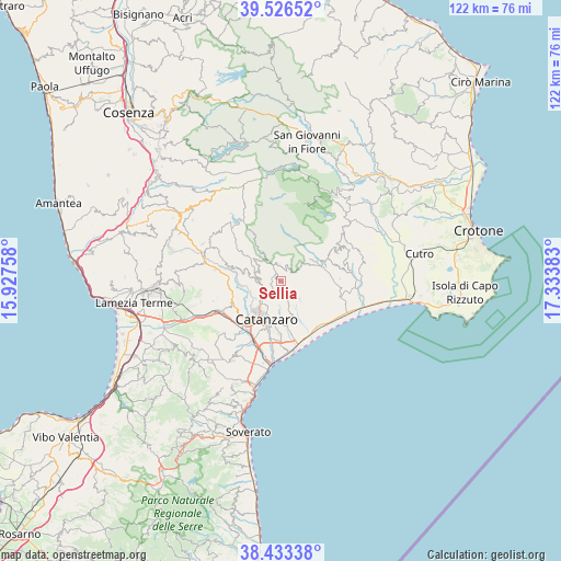
Sellia GPS coordinates[2]
38° 58' 55.416" North, 16° 37' 50.52" East
| Map corner | latitude | longitude |
|---|---|---|
| Upper-left | 39.52652°, | 15.92758° |
| Center: | 38.98206°, | 16.6307° |
| Lower-right: | 38.43338°, | 17.33383° |
| Map W x H: | 121.5×121.5 km | = 75.5×75.5mi |
| max Lat: | 47.04031° ⇑92.7% North |
| Sellia: | 38.98206° |
| min Lat: | ⇓7.3% South 35.50142° |
| min Long | Sellia | max Long |
| 6.69888° | 16.6307° | 18.48682° |
| W 97.1%⇐ | ⇒2.9% E |
Elevation
Elevation of Sellia is 492 m = 1614 ft, and this is 185.3 m = 608 ft above average elevation for this country.
| Max E: |
2085 m = 6841 ft | 22% |
| Sellia | 492 m 1614 ft | |
| Avg. | 306.7 m = 1006 ft | |
Min E: |
-4 m = -13 ft | 78% |
See also: Italy elevation on elevation.city.
Geographical zone
Sellia is located in North temperate zone (between Tropic of Cancer and the Arctic Circle). Distance of this Northern Tropic circle is 1728.5 km =1074 mi to South.| Distance of | km | miles | from Sellia |
|---|---|---|---|
| North Pole | 5672.7 | 3524.9 | to North |
| Arctic Circle | 3066.8 | 1905.6 | to North |
| Tropic Cancer | 1728.5 | 1074 | to South |
| Equator | 4334.4 | 2693.3 | to South |


Nearby cities:
15 places around Sellia: (largest is in red/bold)
• Albi
5.5 km =3.4 mi,  328°
328°
• Cava-Cuculera Nobile
9.8 km =6.1 mi,  184°
184°
• Cavora-Lenticchia
7.2 km =4.5 mi,  242°
242°
• Crichi
3.4 km =2.1 mi,  163°
163°
• Fossato Serralta
4.7 km =2.9 mi,  289°
289°
• Gimigliano
8.6 km =5.3 mi,  263°
263°
• Magisano
3.5 km =2.2 mi,  356°
356°
• Pentone
4.2 km =2.6 mi,  275°
275°
• Sant'Elia
4.8 km =3 mi, 235°
• Sersale
9.1 km =5.7 mi,  69°
69°
• Siano
7.8 km =4.8 mi,  198°
198°
• Sorbo San Basile
6.7 km =4.2 mi,  307°
307°
• Soveria Simeri
5.5 km =3.4 mi,  130°
130°
• Taverna
6.2 km =3.9 mi,  315°
315°
• Zagarise
3.5 km =2.2 mi,  55°
55°
Sources, notices
• [Note1] Compared only with cities in Italy existing in our database
• [Src1] Map data: © OpenStreetMap contributors (CC-BY-SA)
• [Src2] Other city data from geonames.org with taken over terms of usage.
• [Src3] Geographical zone / Annual Mean Temperature by Robert A. Rohde @ Wikipedia
