San Lorenzo del Vallo geodata
San Lorenzo del Vallo (Calabria) is a seat of a third-order administrative division; located in Italy in Europe/Rome (GMT+2) time zone. With population of 2,386 people, there are 3654 cities with bigger population in this country. Compared to other cities in Italy, 89.6% of cities are located further ↑North; 95.2% of cities are located further ←West and 63.8% of cities have lower elevation than San Lorenzo del Vallo. Note1
Administrative division(s):
- Level 1: Calabria
- Level 2: Provincia di Cosenza
- Level 3: San Lorenzo del Vallo
Current local time in San Lorenzo del Vallo:
06:59 PM, WednesdayDifference from your time zone: hours


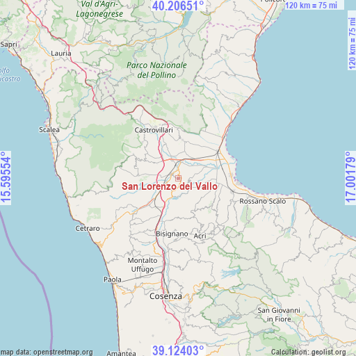
San Lorenzo del Vallo GPS coordinates[2]
39° 40' 2.604" North, 16° 17' 55.176" East
| Map corner | latitude | longitude |
|---|---|---|
| Upper-left | 40.20651°, | 15.59554° |
| Center: | 39.66739°, | 16.29866° |
| Lower-right: | 39.12403°, | 17.00179° |
| Map W x H: | 120.4×120.4 km | = 74.8×74.8mi |
| max Lat: | 47.04031° ⇑89.6% North |
| San Lorenzo del Vallo: | 39.66739° |
| min Lat: | ⇓10.4% South 35.50142° |
| min Long | San Lorenzo del | max Long |
| 6.69888° | 16.29866° | 18.48682° |
| W 95.2%⇐ | ⇒4.8% E |
Elevation
Elevation of San Lorenzo del Vallo is 332 m = 1089 ft, and this is 25.3 m = 83 ft above average elevation for this country.
| Max E: |
2085 m = 6841 ft | 36.2% |
| San Lorenzo del Vallo | 332 m 1089 ft | |
| Avg. | 306.7 m = 1006 ft | |
Min E: |
-4 m = -13 ft | 63.8% |
See also: Italy elevation on elevation.city.
Geographical zone
San Lorenzo del Vallo is located in North temperate zone (between Tropic of Cancer and the Arctic Circle). Distance of this Northern Tropic circle is 1804.7 km =1121.4 mi to South.| Distance of | km | miles | from San Lorenzo del Vallo |
|---|---|---|---|
| North Pole | 5596.5 | 3477.5 | to North |
| Arctic Circle | 2990.6 | 1858.3 | to North |
| Tropic Cancer | 1804.7 | 1121.4 | to South |
| Equator | 4410.6 | 2740.6 | to South |


Nearby cities:
15 places around San Lorenzo del Vallo: (largest is in red/bold)
• Apollinara
10.8 km =6.7 mi,  69°
69°
• Cantinella
12.9 km =8 mi,  91°
91°
• Cassano Allo Ionio
12.9 km =8 mi,  10°
10°
• Doria
8.6 km =5.3 mi,  34°
34°
• Firmo
13.1 km =8.1 mi,  297°
297°
• Roggiano Gravina
13 km =8.1 mi,  244°
244°
• San Cosmo Albanese
13.6 km =8.5 mi,  133°
133°
• San Demetrio Corone
12.1 km =7.5 mi,  153°
153°
• San Nico
11.4 km =7.1 mi, 89°
• Santa Sofia d'Epiro
13.7 km =8.5 mi,  169°
169°
• Scalo Ferroviario
10.3 km =6.4 mi,  229°
229°
• Spezzano Albanese
0.9 km =0.6 mi,  82°
82°
• Tarsia
5.4 km =3.4 mi,  203°
203°
• Terranova da Sibari
3.8 km =2.4 mi,  110°
110°
• Vaccarizzo Albanese
14.7 km =9.1 mi, 128°
Sources, notices
• [Note1] Compared only with cities in Italy existing in our database
• [Src1] Map data: © OpenStreetMap contributors (CC-BY-SA)
• [Src2] Other city data from geonames.org with taken over terms of usage.
• [Src3] Geographical zone / Annual Mean Temperature by Robert A. Rohde @ Wikipedia
