Resuttano geodata
Resuttano (Sicily) is a seat of a third-order administrative division; located in Italy in Europe/Rome (GMT+2) time zone. With population of 1,938 people, there are 4264 cities with bigger population in this country. Compared to other cities in Italy, 98.2% of cities are located further ↑North; 78.4% of cities are located further ←West and 83.6% of cities have lower elevation than Resuttano. Note1


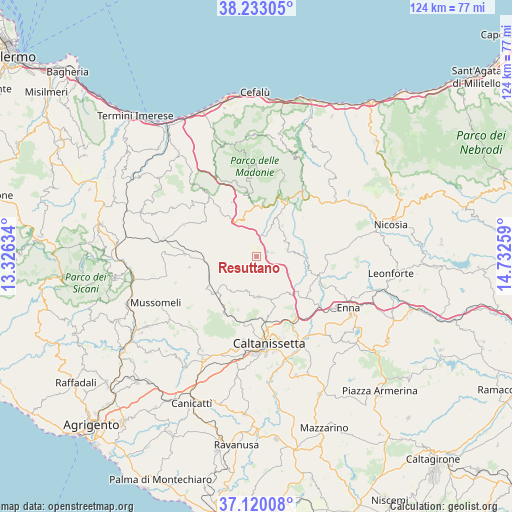
Resuttano GPS coordinates[2]
37° 40' 43.14" North, 14° 1' 46.056" East
| Map corner | latitude | longitude |
|---|---|---|
| Upper-left | 38.23305°, | 13.32634° |
| Center: | 37.67865°, | 14.02946° |
| Lower-right: | 37.12008°, | 14.73259° |
| Map W x H: | 123.8×123.8 km | = 76.9×76.9mi |
| max Lat: | 47.04031° ⇑98.2% North |
| Resuttano: | 37.67865° |
| min Lat: | ⇓1.8% South 35.50142° |
| min Long | Resuttano | max Long |
| 6.69888° | 14.02946° | 18.48682° |
| W 78.4%⇐ | ⇒21.6% E |
Elevation
Elevation of Resuttano is 585 m = 1919 ft, and this is 278.3 m = 913 ft above average elevation for this country.
| Max E: |
2085 m = 6841 ft | 16.4% |
| Resuttano | 585 m 1919 ft | |
| Avg. | 306.7 m = 1006 ft | |
Min E: |
-4 m = -13 ft | 83.6% |
See also: Italy elevation on elevation.city.
Geographical zone
Resuttano is located in North temperate zone (between Tropic of Cancer and the Arctic Circle). Distance of this Northern Tropic circle is 1583.6 km =984 mi to South.| Distance of | km | miles | from Resuttano |
|---|---|---|---|
| North Pole | 5817.6 | 3614.9 | to North |
| Arctic Circle | 3211.7 | 1995.7 | to North |
| Tropic Cancer | 1583.6 | 984 | to South |
| Equator | 4189.5 | 2603.2 | to South |


Nearby cities:
15 places around Resuttano: (largest is in red/bold)
• Alimena
7.6 km =4.7 mi,  77°
77°
• Blufi
9 km =5.6 mi,  25°
25°
• Bompietro
9.3 km =5.8 mi,  38°
38°
• Castellana Sicula
12.1 km =7.5 mi,  4°
4°
• Fasanò-Ss.Trinità-Pianello
12.4 km =7.7 mi, 29°
• Marianopoli
13.4 km =8.3 mi,  228°
228°
• Petralia Soprana
15.2 km =9.4 mi, 27°
• Petralia Sottana
15.6 km =9.7 mi,  21°
21°
• Polizzi Generosa
15 km =9.3 mi,  350°
350°
• Santa Caterina Villarmosa
9.8 km =6.1 mi,  176°
176°
• Valledolmo
19.3 km =12 mi,  293°
293°
• Vallelunga Pratameno
17.4 km =10.8 mi,  271°
271°
• Villalba
16.5 km =10.3 mi,  260°
260°
• Villapriolo
15.4 km =9.6 mi,  110°
110°
• Villarosa
16.1 km =10 mi,  129°
129°
Sources, notices
• [Note1] Compared only with cities in Italy existing in our database
• [Src1] Map data: © OpenStreetMap contributors (CC-BY-SA)
• [Src2] Other city data from geonames.org with taken over terms of usage.
• [Src3] Geographical zone / Annual Mean Temperature by Robert A. Rohde @ Wikipedia
