Mongrassano geodata
Mongrassano (Calabria) is a seat of a third-order administrative division; located in Italy in Europe/Rome (GMT+1) time zone. With population of 563 people, there are 9320 cities with bigger population in this country. Compared to other cities in Italy, 90.2% of cities are located further ↑North; 93.7% of cities are located further ←West and 79.5% of cities have lower elevation than Mongrassano. Note1


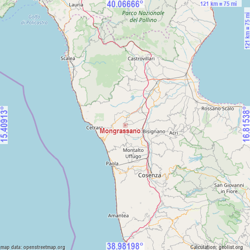
Mongrassano GPS coordinates[2]
39° 31' 35.184" North, 16° 6' 44.1" East
| Map corner | latitude | longitude |
|---|---|---|
| Upper-left | 40.06666°, | 15.40913° |
| Center: | 39.52644°, | 16.11225° |
| Lower-right: | 38.98198°, | 16.81538° |
| Map W x H: | 120.6×120.6 km | = 74.9×74.9mi |
| max Lat: | 47.04031° ⇑90.2% North |
| Mongrassano: | 39.52644° |
| min Lat: | ⇓9.8% South 35.50142° |
| min Long | Mongrassano | max Long |
| 6.69888° | 16.11225° | 18.48682° |
| W 93.7%⇐ | ⇒6.3% E |
Elevation
Elevation of Mongrassano is 517 m = 1696 ft, and this is 210.3 m = 690 ft above average elevation for this country.
| Max E: |
2085 m = 6841 ft | 20.5% |
| Mongrassano | 517 m 1696 ft | |
| Avg. | 306.7 m = 1006 ft | |
Min E: |
-4 m = -13 ft | 79.5% |
See also: Italy elevation on elevation.city.
Geographical zone
Mongrassano is located in North temperate zone (between Tropic of Cancer and the Arctic Circle). Distance of this Northern Tropic circle is 1789 km =1111.6 mi to South.| Distance of | km | miles | from Mongrassano |
|---|---|---|---|
| North Pole | 5612.1 | 3487.2 | to North |
| Arctic Circle | 3006.2 | 1868 | to North |
| Tropic Cancer | 1789 | 1111.6 | to South |
| Equator | 4394.9 | 2730.9 | to South |


Nearby cities:
15 places around Mongrassano: (largest is in red/bold)
• Casello dei Morti
7.9 km =4.9 mi,  2°
2°
• Cervicati
2.2 km =1.4 mi,  35°
35°
• Cerzeto
2.1 km =1.3 mi,  171°
171°
• Fagnano Castello
6.6 km =4.1 mi,  319°
319°
• Lattarico
8.5 km =5.3 mi, 171°
• Malvito
9.7 km =6 mi,  328°
328°
• Roggiano Gravina
11 km =6.8 mi,  22°
22°
• Rota Greca
6.6 km =4.1 mi,  178°
178°
• San Giacomo
3 km =1.9 mi, 177°
• San Marco Argentano
3.6 km =2.2 mi, 17°
• San Martino di Finita
4.1 km =2.5 mi, 183°
• Santa Caterina Albanese
7.5 km =4.7 mi, 331°
• Santa Maria le Grotte
6.1 km =3.8 mi,  154°
154°
• Sartano
6 km =3.7 mi,  105°
105°
• Torano Castello
4.9 km =3 mi,  120°
120°
Sources, notices
• [Note1] Compared only with cities in Italy existing in our database
• [Src1] Map data: © OpenStreetMap contributors (CC-BY-SA)
• [Src2] Other city data from geonames.org with taken over terms of usage.
• [Src3] Geographical zone / Annual Mean Temperature by Robert A. Rohde @ Wikipedia
