Mangone geodata
Mangone (Calabria) is a seat of a third-order administrative division; located in Italy in Europe/Rome (GMT+2) time zone. With population of 580 people, there are 9180 cities with bigger population in this country. Compared to other cities in Italy, 91.8% of cities are located further ↑North; 95.5% of cities are located further ←West and 91.4% of cities have lower elevation than Mangone. Note1


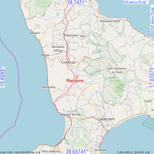
Mangone GPS coordinates[2]
39° 12' 15.732" North, 16° 19' 57.432" East
| Map corner | latitude | longitude |
|---|---|---|
| Upper-left | 39.7471°, | 15.6295° |
| Center: | 39.20437°, | 16.33262° |
| Lower-right: | 38.65741°, | 17.03575° |
| Map W x H: | 121.2×121.2 km | = 75.3×75.3mi |
| max Lat: | 47.04031° ⇑91.8% North |
| Mangone: | 39.20437° |
| min Lat: | ⇓8.2% South 35.50142° |
| min Long | Mangone | max Long |
| 6.69888° | 16.33262° | 18.48682° |
| W 95.5%⇐ | ⇒4.5% E |
Elevation
Elevation of Mangone is 753 m = 2470 ft, and this is 446.3 m = 1464 ft above average elevation for this country.
| Max E: |
2085 m = 6841 ft | 8.6% |
| Mangone | 753 m 2470 ft | |
| Avg. | 306.7 m = 1006 ft | |
Min E: |
-4 m = -13 ft | 91.4% |
See also: Italy elevation on elevation.city.
Geographical zone
Mangone is located in North temperate zone (between Tropic of Cancer and the Arctic Circle). Distance of this Northern Tropic circle is 1753.2 km =1089.4 mi to South.| Distance of | km | miles | from Mangone |
|---|---|---|---|
| North Pole | 5647.9 | 3509.4 | to North |
| Arctic Circle | 3042.1 | 1890.3 | to North |
| Tropic Cancer | 1753.2 | 1089.4 | to South |
| Equator | 4359.1 | 2708.6 | to South |


Nearby cities:
15 places around Mangone: (largest is in red/bold)
• Aprigliano
4.3 km =2.7 mi,  9°
9°
• Belsito
5 km =3.1 mi,  231°
231°
• Carpanzano
6.7 km =4.2 mi,  201°
201°
• Cellara
1.6 km =1 mi, 6°
• Donnici Inferiore
6.1 km =3.8 mi,  326°
326°
• Donnici Superiore
5.5 km =3.4 mi, 332°
• Figline Vegliaturo
2.3 km =1.4 mi,  355°
355°
• Marzi
4.4 km =2.7 mi,  210°
210°
• Paterno Calabro
6.4 km =4 mi,  294°
294°
• Piane Crati
3.5 km =2.2 mi,  346°
346°
• Pietrafitta
6.3 km =3.9 mi, 5°
• Rogliano
3.2 km =2 mi, 204°
• Sant'Ippolito
7.7 km =4.8 mi, 334°
• Santo Stefano di Rogliano
1.7 km =1.1 mi,  217°
217°
• Vallegianno
2.4 km =1.5 mi,  256°
256°
Sources, notices
• [Note1] Compared only with cities in Italy existing in our database
• [Src1] Map data: © OpenStreetMap contributors (CC-BY-SA)
• [Src2] Other city data from geonames.org with taken over terms of usage.
• [Src3] Geographical zone / Annual Mean Temperature by Robert A. Rohde @ Wikipedia
