Lungro geodata
Lungro (Calabria) is a seat of a third-order administrative division; located in Italy in Europe/Rome (GMT+2) time zone. With population of 2,473 people, there are 3554 cities with bigger population in this country. Compared to other cities in Italy, 89.3% of cities are located further ↑North; 93.8% of cities are located further ←West and 82.6% of cities have lower elevation than Lungro. Note1


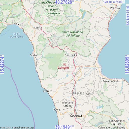
Lungro GPS coordinates[2]
39° 44' 15.792" North, 16° 7' 33.096" East
| Map corner | latitude | longitude |
|---|---|---|
| Upper-left | 40.27628°, | 15.42274° |
| Center: | 39.73772°, | 16.12586° |
| Lower-right: | 39.19491°, | 16.82899° |
| Map W x H: | 120.2×120.2 km | = 74.7×74.7mi |
| max Lat: | 47.04031° ⇑89.3% North |
| Lungro: | 39.73772° |
| min Lat: | ⇓10.7% South 35.50142° |
| min Long | Lungro | max Long |
| 6.69888° | 16.12586° | 18.48682° |
| W 93.8%⇐ | ⇒6.2% E |
Elevation
Elevation of Lungro is 564 m = 1850 ft, and this is 257.3 m = 844 ft above average elevation for this country.
| Max E: |
2085 m = 6841 ft | 17.4% |
| Lungro | 564 m 1850 ft | |
| Avg. | 306.7 m = 1006 ft | |
Min E: |
-4 m = -13 ft | 82.6% |
See also: Italy elevation on elevation.city.
Geographical zone
Lungro is located in North temperate zone (between Tropic of Cancer and the Arctic Circle). Distance of this Northern Tropic circle is 1812.5 km =1126.2 mi to South.| Distance of | km | miles | from Lungro |
|---|---|---|---|
| North Pole | 5588.6 | 3472.6 | to North |
| Arctic Circle | 2982.8 | 1853.4 | to North |
| Tropic Cancer | 1812.5 | 1126.2 | to South |
| Equator | 4418.4 | 2745.5 | to South |


Nearby cities:
15 places around Lungro: (largest is in red/bold)
• Acquaformosa
3.4 km =2.1 mi,  240°
240°
• Altomonte
4.3 km =2.7 mi,  175°
175°
• Casello dei Morti
15.7 km =9.8 mi, 182°
• Castrovillari
10.9 km =6.8 mi,  36°
36°
• Firmo
3.7 km =2.3 mi,  118°
118°
• Frascineto
15.9 km =9.9 mi,  47°
47°
• Malvito
16.4 km =10.2 mi,  202°
202°
• Morano Calabro
11.6 km =7.2 mi,  5°
5°
• Mottafollone
11.2 km =7 mi,  207°
207°
• Roggiano Gravina
13.7 km =8.5 mi,  167°
167°
• San Basile
8.6 km =5.3 mi,  21°
21°
• San Donato di Ninea
7.3 km =4.5 mi,  246°
246°
• San Sosti
12 km =7.5 mi,  223°
223°
• Saracena
5.4 km =3.4 mi,  32°
32°
• Scalo Ferroviario
16.1 km =10 mi,  154°
154°
Sources, notices
• [Note1] Compared only with cities in Italy existing in our database
• [Src1] Map data: © OpenStreetMap contributors (CC-BY-SA)
• [Src2] Other city data from geonames.org with taken over terms of usage.
• [Src3] Geographical zone / Annual Mean Temperature by Robert A. Rohde @ Wikipedia
