Caltabellotta geodata
Caltabellotta (Sicily) is a seat of a third-order administrative division; located in Italy in Europe/Rome (GMT+2) time zone. With population of 3,267 people, there are 2856 cities with bigger population in this country. Compared to other cities in Italy, 98.6% of cities are located further ↑North; 70.5% of cities are located further ←West and 92.4% of cities have lower elevation than Caltabellotta. Note1


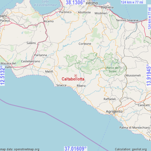
Caltabellotta GPS coordinates[2]
37° 34' 31.548" North, 13° 12' 58.752" East
| Map corner | latitude | longitude |
|---|---|---|
| Upper-left | 38.1306°, | 12.5132° |
| Center: | 37.57543°, | 13.21632° |
| Lower-right: | 37.01609°, | 13.91945° |
| Map W x H: | 123.9×123.9 km | = 77×77mi |
| max Lat: | 47.04031° ⇑98.6% North |
| Caltabellotta: | 37.57543° |
| min Lat: | ⇓1.4% South 35.50142° |
| min Long | Caltabellotta | max Long |
| 6.69888° | 13.21632° | 18.48682° |
| W 70.5%⇐ | ⇒29.5% E |
Elevation
Elevation of Caltabellotta is 782 m = 2566 ft, and this is 475.3 m = 1559 ft above average elevation for this country.
| Max E: |
2085 m = 6841 ft | 7.6% |
| Caltabellotta | 782 m 2566 ft | |
| Avg. | 306.7 m = 1006 ft | |
Min E: |
-4 m = -13 ft | 92.4% |
See also: Italy elevation on elevation.city.
Geographical zone
Caltabellotta is located in North temperate zone (between Tropic of Cancer and the Arctic Circle). Distance of this Northern Tropic circle is 1572.1 km =976.9 mi to South.| Distance of | km | miles | from Caltabellotta |
|---|---|---|---|
| North Pole | 5829.1 | 3622 | to North |
| Arctic Circle | 3223.2 | 2002.8 | to North |
| Tropic Cancer | 1572.1 | 976.9 | to South |
| Equator | 4178 | 2596.1 | to South |


Nearby cities:
15 places around Caltabellotta: (largest is in red/bold)
• Bisacquino
14.8 km =9.2 mi,  15°
15°
• Burgio
6.9 km =4.3 mi,  65°
65°
• Calamonaci
8.6 km =5.3 mi,  130°
130°
• Chiusa Sclafani
12.3 km =7.6 mi, 23°
• Cianciana
20.1 km =12.5 mi,  108°
108°
• Contessa Entellina
17.4 km =10.8 mi,  350°
350°
• Giuliana
11 km =6.8 mi,  9°
9°
• Lucca Sicula
7.9 km =4.9 mi,  88°
88°
• Palazzo Adriano
18.5 km =11.5 mi,  50°
50°
• Ribera
9.7 km =6 mi,  152°
152°
• Sambuca di Sicilia
12.4 km =7.7 mi,  313°
313°
• Sant'Anna
2.4 km =1.5 mi,  137°
137°
• Sciacca
13.9 km =8.6 mi,  236°
236°
• Secca Grande
15.8 km =9.8 mi,  171°
171°
• Villafranca Sicula
6.7 km =4.2 mi,  78°
78°
Sources, notices
• [Note1] Compared only with cities in Italy existing in our database
• [Src1] Map data: © OpenStreetMap contributors (CC-BY-SA)
• [Src2] Other city data from geonames.org with taken over terms of usage.
• [Src3] Geographical zone / Annual Mean Temperature by Robert A. Rohde @ Wikipedia
