Alia geodata
Alia (Sicily) is a seat of a third-order administrative division; located in Italy in Europe/Rome (GMT+2) time zone. With population of 3,504 people, there are 2680 cities with bigger population in this country. Compared to other cities in Italy, 97.8% of cities are located further ↑North; 75.7% of cities are located further ←West and 90.4% of cities have lower elevation than Alia. Note1


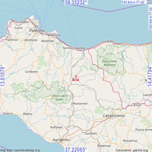
Alia GPS coordinates[2]
37° 46' 43.212" North, 13° 42' 50.076" East
| Map corner | latitude | longitude |
|---|---|---|
| Upper-left | 38.33232°, | 13.01079° |
| Center: | 37.77867°, | 13.71391° |
| Lower-right: | 37.22085°, | 14.41704° |
| Map W x H: | 123.6×123.6 km | = 76.8×76.8mi |
| max Lat: | 47.04031° ⇑97.8% North |
| Alia: | 37.77867° |
| min Lat: | ⇓2.2% South 35.50142° |
| min Long | Alia | max Long |
| 6.69888° | 13.71391° | 18.48682° |
| W 75.7%⇐ | ⇒24.3% E |
Elevation
Elevation of Alia is 729 m = 2392 ft, and this is 422.3 m = 1385 ft above average elevation for this country.
| Max E: |
2085 m = 6841 ft | 9.6% |
| Alia | 729 m 2392 ft | |
| Avg. | 306.7 m = 1006 ft | |
Min E: |
-4 m = -13 ft | 90.4% |
See also: Italy elevation on elevation.city.
Geographical zone
Alia is located in North temperate zone (between Tropic of Cancer and the Arctic Circle). Distance of this Northern Tropic circle is 1594.7 km =990.9 mi to South.| Distance of | km | miles | from Alia |
|---|---|---|---|
| North Pole | 5806.5 | 3608 | to North |
| Arctic Circle | 3200.6 | 1988.8 | to North |
| Tropic Cancer | 1594.7 | 990.9 | to South |
| Equator | 4200.6 | 2610.1 | to South |


Nearby cities:
15 places around Alia: (largest is in red/bold)
• Aliminusa
11.2 km =7 mi,  31°
31°
• Caccamo
17.7 km =11 mi,  346°
346°
• Caltavuturo
16.3 km =10.1 mi,  73°
73°
• Cammarata
17.8 km =11.1 mi,  205°
205°
• Castronuovo di Sicilia
14.7 km =9.1 mi,  221°
221°
• Cerda
16.7 km =10.4 mi, 32°
• Lercara Friddi
10.3 km =6.4 mi,  249°
249°
• Montemaggiore Belsito
8.8 km =5.5 mi, 28°
• Roccapalumba
7.5 km =4.7 mi,  295°
295°
• San Giovanni Gemini
17.9 km =11.1 mi,  200°
200°
• Sciara
15.7 km =9.8 mi,  15°
15°
• Sclafani Bagni
13.3 km =8.3 mi, 68°
• Valledolmo
10.6 km =6.6 mi,  109°
109°
• Vallelunga Pratameno
14.9 km =9.3 mi,  136°
136°
• Vicari
13.7 km =8.5 mi,  291°
291°
Sources, notices
• [Note1] Compared only with cities in Italy existing in our database
• [Src1] Map data: © OpenStreetMap contributors (CC-BY-SA)
• [Src2] Other city data from geonames.org with taken over terms of usage.
• [Src3] Geographical zone / Annual Mean Temperature by Robert A. Rohde @ Wikipedia
