Villachiara geodata
Villachiara (Lombardy) is a seat of a third-order administrative division; located in Italy in Europe/Rome (GMT+2) time zone. With population of 1,068 people, there are 6406 cities with bigger population in this country. Compared to other cities in Italy, 68.9% of cities are located further ↓South; 68.5% of cities are located further →East and 74.9% of cities have higher elevation than Villachiara. Note1


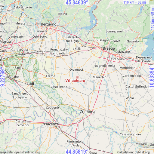
Villachiara GPS coordinates[2]
45° 21' 16.02" North, 9° 55' 50.916" East
| Map corner | latitude | longitude |
|---|---|---|
| Upper-left | 45.84639°, | 9.22769° |
| Center: | 45.35445°, | 9.93081° |
| Lower-right: | 44.85819°, | 10.63394° |
| Map W x H: | 109.9×109.9 km | = 68.3×68.3mi |
| max Lat: | 47.04031° ⇑31.1% North |
| Villachiara: | 45.35445° |
| min Lat: | ⇓68.9% South 35.50142° |
| min Long | Villachiara | max Long |
| 6.69888° | 9.93081° | 18.48682° |
| W 31.5%⇐ | ⇒68.5% E |
Elevation
Elevation of Villachiara is 74 m = 243 ft, and this is 232.7 m = 763 ft below average elevation for this country.
| Max E: |
2085 m = 6841 ft | 74.9% |
| Avg. | 306.7 m = 1006 ft | |
| Villachiara | 74 m = 243 ft | |
Min E: |
-4 m = -13 ft | 25.1% |
See also: Italy elevation on elevation.city.
Geographical zone
Villachiara is located in North temperate zone (between Tropic of Cancer and the Arctic Circle). Distance of this North polar circle is 2358.2 km =1465.3 mi to North.| Distance of | km | miles | from Villachiara |
|---|---|---|---|
| North Pole | 4964.1 | 3084.5 | to North |
| Arctic Circle | 2358.2 | 1465.3 | to North |
| Tropic Cancer | 2437 | 1514.3 | to South |
| Equator | 5042.9 | 3133.5 | to South |


Nearby cities:
15 places around Villachiara: (largest is in red/bold)
• Azzanello
4.7 km =2.9 mi,  190°
190°
• Borgo San Giacomo
3 km =1.9 mi,  103°
103°
• Casalmorano
7.8 km =4.8 mi,  198°
198°
• Castelvisconti
5.5 km =3.4 mi,  171°
171°
• Coniolo
4.8 km =3 mi,  47°
47°
• Cumignano sul Naviglio
7.4 km =4.6 mi,  270°
270°
• Farfengo
4.1 km =2.5 mi,  68°
68°
• Genivolta
4.8 km =3 mi,  239°
239°
• Motella
6.3 km =3.9 mi, 99°
• Orzinuovi
5.3 km =3.3 mi,  353°
353°
• Orzivecchi
7.8 km =4.8 mi,  19°
19°
• Quinzano d'Oglio
7.5 km =4.7 mi,  126°
126°
• San Paolo
7.5 km =4.7 mi, 74°
• Soncino
7.1 km =4.4 mi,  316°
316°
• Ticengo
8.2 km =5.1 mi,  281°
281°
Sources, notices
• [Note1] Compared only with cities in Italy existing in our database
• [Src1] Map data: © OpenStreetMap contributors (CC-BY-SA)
• [Src2] Other city data from geonames.org with taken over terms of usage.
• [Src3] Geographical zone / Annual Mean Temperature by Robert A. Rohde @ Wikipedia
