Selci geodata
Selci (Latium) is a seat of a third-order administrative division; located in Italy in Europe/Rome (GMT+2) time zone. With population of 623 people, there are 8818 cities with bigger population in this country. Compared to other cities in Italy, 67.7% of cities are located further ↑North; 64% of cities are located further ←West and 52.5% of cities have lower elevation than Selci. Note1


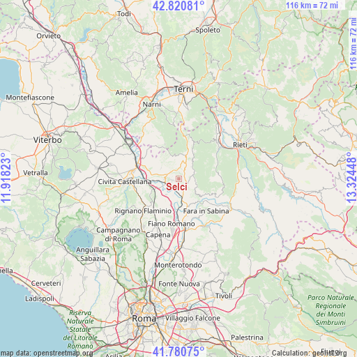
Selci GPS coordinates[2]
42° 18' 10.548" North, 12° 37' 16.86" East
| Map corner | latitude | longitude |
|---|---|---|
| Upper-left | 42.82081°, | 11.91823° |
| Center: | 42.30293°, | 12.62135° |
| Lower-right: | 41.78075°, | 13.32448° |
| Map W x H: | 115.6×115.6 km | = 71.8×71.8mi |
| max Lat: | 47.04031° ⇑67.7% North |
| Selci: | 42.30293° |
| min Lat: | ⇓32.3% South 35.50142° |
| min Long | Selci | max Long |
| 6.69888° | 12.62135° | 18.48682° |
| W 64%⇐ | ⇒36% E |
Elevation
Elevation of Selci is 250 m = 820 ft, and this is 56.7 m = 186 ft below average elevation for this country.
| Max E: |
2085 m = 6841 ft | 47.5% |
| Avg. | 306.7 m = 1006 ft | |
| Selci | 250 m = 820 ft | |
Min E: |
-4 m = -13 ft | 52.5% |
See also: Italy elevation on elevation.city.
Geographical zone
Selci is located in North temperate zone (between Tropic of Cancer and the Arctic Circle). Distance of this Northern Tropic circle is 2097.7 km =1303.4 mi to South.| Distance of | km | miles | from Selci |
|---|---|---|---|
| North Pole | 5303.4 | 3295.4 | to North |
| Arctic Circle | 2697.5 | 1676.1 | to North |
| Tropic Cancer | 2097.7 | 1303.4 | to South |
| Equator | 4703.6 | 2922.7 | to South |


Nearby cities:
15 places around Selci: (largest is in red/bold)
• Cantalupo in Sabina
2 km =1.2 mi,  77°
77°
• Casperia
5.6 km =3.5 mi,  45°
45°
• Collevecchio
6.6 km =4.1 mi,  301°
301°
• Filacciano
5.7 km =3.5 mi,  198°
198°
• Forano
2.3 km =1.4 mi,  255°
255°
• Gavignano Sabino
3.3 km =2.1 mi,  186°
186°
• Poggio Catino
6.4 km =4 mi,  98°
98°
• Poggio Mirteto
6.8 km =4.2 mi,  125°
125°
• Poggio Mirteto Scalo
5.7 km =3.5 mi,  164°
164°
• Ponzano Romano
6.6 km =4.1 mi,  219°
219°
• Roccantica
6.3 km =3.9 mi,  71°
71°
• Stimigliano
4.8 km =3 mi,  267°
267°
• Tarano
6.3 km =3.9 mi,  339°
339°
• Torri in Sabina
5.6 km =3.5 mi,  17°
17°
• Torrita Tiberina
7.2 km =4.5 mi,  183°
183°
Sources, notices
• [Note1] Compared only with cities in Italy existing in our database
• [Src1] Map data: © OpenStreetMap contributors (CC-BY-SA)
• [Src2] Other city data from geonames.org with taken over terms of usage.
• [Src3] Geographical zone / Annual Mean Temperature by Robert A. Rohde @ Wikipedia
