Racines geodata
Racines (Trentino-Alto Adige) is a populated place; located in Italy in Europe/Rome (GMT+2) time zone. With population of 4,128 people, there are 2324 cities with bigger population in this country. Compared to other cities in Italy, 99.8% of cities are located further ↓South; 53.1% of cities are located further →East and 99.4% of cities have lower elevation than Racines. Note1
Administrative division(s):
- Level 1: Trentino-Alto Adige
- Level 2: Bolzano
- Level 3: Racines - Ratschings


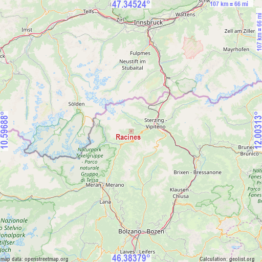
Racines GPS coordinates[2]
46° 52' 0.012" North, 11° 18' 0" East
| Map corner | latitude | longitude |
|---|---|---|
| Upper-left | 47.34524°, | 10.59688° |
| Center: | 46.86667°, | 11.3° |
| Lower-right: | 46.38379°, | 12.00313° |
| Map W x H: | 106.9×106.9 km | = 66.4×66.4mi |
| max Lat: | 47.04031° ⇑0.2% North |
| Racines: | 46.86667° |
| min Lat: | ⇓99.8% South 35.50142° |
| min Long | Racines | max Long |
| 6.69888° | 11.3° | 18.48682° |
| W 46.9%⇐ | ⇒53.1% E |
Elevation
Elevation of Racines is 1377 m = 4518 ft, and this is 1070.3 m = 3511 ft above average elevation for this country.
| Max E: |
2085 m = 6841 ft | 0.59999999999999% |
| Racines | 1377 m 4518 ft | |
| Avg. | 306.7 m = 1006 ft | |
Min E: |
-4 m = -13 ft | 99.4% |
See also: Italy elevation on elevation.city.
Geographical zone
Racines is located in North temperate zone (between Tropic of Cancer and the Arctic Circle). Distance of this North polar circle is 2190.1 km =1360.9 mi to North.| Distance of | km | miles | from Racines |
|---|---|---|---|
| North Pole | 4796 | 2980.1 | to North |
| Arctic Circle | 2190.1 | 1360.9 | to North |
| Tropic Cancer | 2605.2 | 1618.8 | to South |
| Equator | 5211.1 | 3238 | to South |


Nearby cities:
15 places around Racines: (largest is in red/bold)
• Brennero - Brenner
13.4 km =8.3 mi,  53°
53°
• Campo di Trens
14.2 km =8.8 mi,  86°
86°
• Casateia
8.3 km =5.2 mi,  77°
77°
• Colle Isarco
13.5 km =8.4 mi, 53°
• Mareta
4.7 km =2.9 mi, 52°
• Moso in Passiria
10.8 km =6.7 mi,  248°
248°
• Prati
13.1 km =8.1 mi,  73°
73°
• Racines - Ratschings
6.2 km =3.9 mi, 74°
• Ried
18.4 km =11.4 mi, 67°
• Rifiano
20.4 km =12.7 mi,  206°
206°
• San Leonardo in Passiria
7.3 km =4.5 mi, 214°
• San Martino in Passiria
10.7 km =6.6 mi, 211°
• Stanghe
6.1 km =3.8 mi, 73°
• Stazione
11.2 km =7 mi, 73°
• Vipiteno
10.3 km =6.4 mi, 73°
Sources, notices
• [Note1] Compared only with cities in Italy existing in our database
• [Src1] Map data: © OpenStreetMap contributors (CC-BY-SA)
• [Src2] Other city data from geonames.org with taken over terms of usage.
• [Src3] Geographical zone / Annual Mean Temperature by Robert A. Rohde @ Wikipedia
