Piazzatorre geodata
Piazzatorre (Lombardy) is a seat of a third-order administrative division; located in Italy in Europe/Rome (GMT+2) time zone. With population of 437 people, there are 10134 cities with bigger population in this country. Compared to other cities in Italy, 91.8% of cities are located further ↓South; 70.8% of cities are located further →East and 95.9% of cities have lower elevation than Piazzatorre. Note1


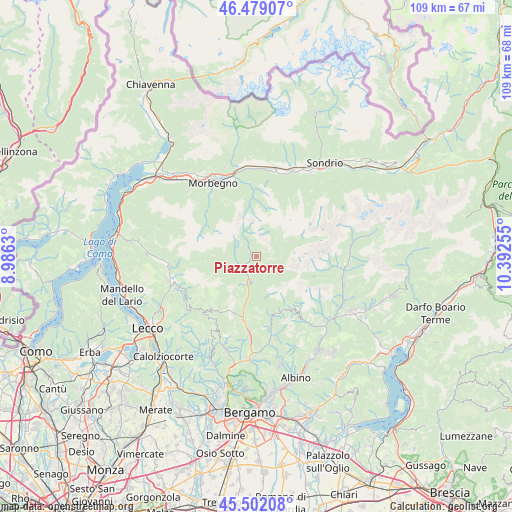
Piazzatorre GPS coordinates[2]
45° 59' 33.828" North, 9° 41' 21.912" East
| Map corner | latitude | longitude |
|---|---|---|
| Upper-left | 46.47907°, | 8.9863° |
| Center: | 45.99273°, | 9.68942° |
| Lower-right: | 45.50208°, | 10.39255° |
| Map W x H: | 108.6×108.6 km | = 67.5×67.5mi |
| max Lat: | 47.04031° ⇑8.2% North |
| Piazzatorre: | 45.99273° |
| min Lat: | ⇓91.8% South 35.50142° |
| min Long | Piazzatorre | max Long |
| 6.69888° | 9.68942° | 18.48682° |
| W 29.2%⇐ | ⇒70.8% E |
Elevation
Elevation of Piazzatorre is 929 m = 3048 ft, and this is 622.3 m = 2042 ft above average elevation for this country.
| Max E: |
2085 m = 6841 ft | 4.1% |
| Piazzatorre | 929 m 3048 ft | |
| Avg. | 306.7 m = 1006 ft | |
Min E: |
-4 m = -13 ft | 95.9% |
See also: Italy elevation on elevation.city.
Geographical zone
Piazzatorre is located in North temperate zone (between Tropic of Cancer and the Arctic Circle). Distance of this North polar circle is 2287.3 km =1421.3 mi to North.| Distance of | km | miles | from Piazzatorre |
|---|---|---|---|
| North Pole | 4893.1 | 3040.4 | to North |
| Arctic Circle | 2287.3 | 1421.3 | to North |
| Tropic Cancer | 2508 | 1558.4 | to South |
| Equator | 5113.9 | 3177.6 | to South |


Nearby cities:
15 places around Piazzatorre: (largest is in red/bold)
• Averara
4.5 km =2.8 mi,  263°
263°
• Branzi
5.5 km =3.4 mi,  78°
78°
• Cassiglio
6.6 km =4.1 mi,  244°
244°
• Colla-Muggiasca
5.3 km =3.3 mi, 258°
• Isola di Fondra
4.7 km =2.9 mi,  109°
109°
• Lenna
5.6 km =3.5 mi,  188°
188°
• Mezzoldo
2.9 km =1.8 mi,  320°
320°
• Moio de' Calvi
4.6 km =2.9 mi,  169°
169°
• Olmo al Brembo
3.9 km =2.4 mi,  230°
230°
• Piazza Brembana
5.2 km =3.2 mi, 193°
• Piazzolo
2 km =1.2 mi, 225°
• Roncobello
6.4 km =4 mi,  130°
130°
• Santa Brigida
5.3 km =3.3 mi, 260°
• Valleve
5.8 km =3.6 mi,  46°
46°
• Valnegra
4.9 km =3 mi,  180°
180°
Sources, notices
• [Note1] Compared only with cities in Italy existing in our database
• [Src1] Map data: © OpenStreetMap contributors (CC-BY-SA)
• [Src2] Other city data from geonames.org with taken over terms of usage.
• [Src3] Geographical zone / Annual Mean Temperature by Robert A. Rohde @ Wikipedia
