Murisengo geodata
Murisengo (Piedmont) is a seat of a third-order administrative division; located in Italy in Europe/Rome (GMT+2) time zone. With population of 753 people, there are 7932 cities with bigger population in this country. Compared to other cities in Italy, 62% of cities are located further ↓South; 91.8% of cities are located further →East and 56.2% of cities have lower elevation than Murisengo. Note1


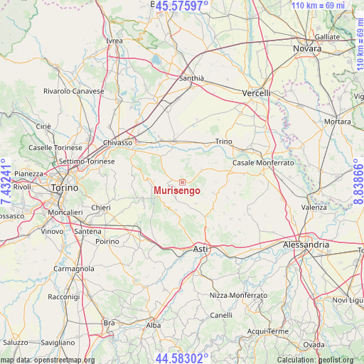
Murisengo GPS coordinates[2]
45° 4' 53.94" North, 8° 8' 7.944" East
| Map corner | latitude | longitude |
|---|---|---|
| Upper-left | 45.57597°, | 7.43241° |
| Center: | 45.08165°, | 8.13554° |
| Lower-right: | 44.58302°, | 8.83866° |
| Map W x H: | 110.4×110.4 km | = 68.6×68.6mi |
| max Lat: | 47.04031° ⇑38% North |
| Murisengo: | 45.08165° |
| min Lat: | ⇓62% South 35.50142° |
| min Long | Murisengo | max Long |
| 6.69888° | 8.13554° | 18.48682° |
| W 8.2%⇐ | ⇒91.8% E |
Elevation
Elevation of Murisengo is 273 m = 896 ft, and this is 33.7 m = 111 ft below average elevation for this country.
| Max E: |
2085 m = 6841 ft | 43.8% |
| Avg. | 306.7 m = 1006 ft | |
| Murisengo | 273 m = 896 ft | |
Min E: |
-4 m = -13 ft | 56.2% |
See also: Italy elevation on elevation.city.
Geographical zone
Murisengo is located in North temperate zone (between Tropic of Cancer and the Arctic Circle). Distance of this North polar circle is 2388.6 km =1484.2 mi to North.| Distance of | km | miles | from Murisengo |
|---|---|---|---|
| North Pole | 4994.5 | 3103.4 | to North |
| Arctic Circle | 2388.6 | 1484.2 | to North |
| Tropic Cancer | 2406.7 | 1495.5 | to South |
| Equator | 5012.6 | 3114.7 | to South |


Nearby cities:
15 places around Murisengo: (largest is in red/bold)
• Alfiano Natta
6.7 km =4.2 mi,  123°
123°
• Brozolo
6.4 km =4 mi,  308°
308°
• Cerrina
7.6 km =4.7 mi,  54°
54°
• Cocconato
7.5 km =4.7 mi,  274°
274°
• Cunico
5.6 km =3.5 mi,  214°
214°
• Montiglio
3.5 km =2.2 mi,  236°
236°
• Odalengo Grande
4 km =2.5 mi,  39°
39°
• Odalengo Piccolo
5.6 km =3.5 mi,  101°
101°
• Piea
7.9 km =4.9 mi,  219°
219°
• Piovà Massaia
7.3 km =4.5 mi,  246°
246°
• Robella
3.5 km =2.2 mi, 310°
• Tonco
7.7 km =4.8 mi,  146°
146°
• Valle Cerrina
7 km =4.3 mi,  58°
58°
• Villadeati
2.7 km =1.7 mi,  112°
112°
• Villamiroglio
6.5 km =4 mi,  25°
25°
Sources, notices
• [Note1] Compared only with cities in Italy existing in our database
• [Src1] Map data: © OpenStreetMap contributors (CC-BY-SA)
• [Src2] Other city data from geonames.org with taken over terms of usage.
• [Src3] Geographical zone / Annual Mean Temperature by Robert A. Rohde @ Wikipedia
