Montecelio geodata
Montecelio (Latium) is a populated place; located in Italy in Europe/Rome (GMT+2) time zone. With population of 3,165 people, there are 2919 cities with bigger population in this country. Compared to other cities in Italy, 70.1% of cities are located further ↑North; 65.5% of cities are located further ←West and 63.3% of cities have lower elevation than Montecelio. Note1
Administrative division(s):
- Level 1: Latium
- Level 2: Città metropolitana di Roma Capitale
- Level 3: Guidonia Montecelio


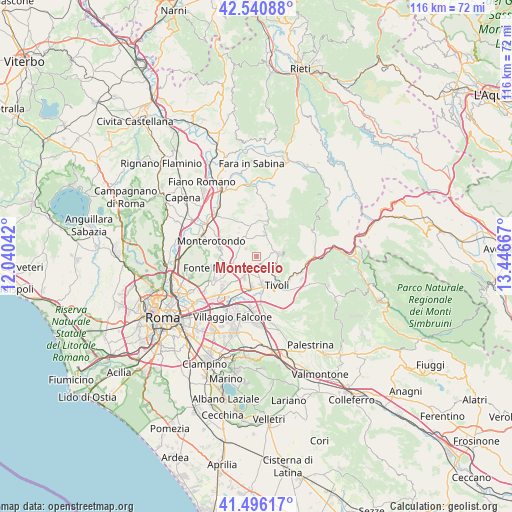
Montecelio GPS coordinates[2]
42° 1' 14.412" North, 12° 44' 36.744" East
| Map corner | latitude | longitude |
|---|---|---|
| Upper-left | 42.54088°, | 12.04042° |
| Center: | 42.02067°, | 12.74354° |
| Lower-right: | 41.49617°, | 13.44667° |
| Map W x H: | 116.2×116.2 km | = 72.2×72.2mi |
| max Lat: | 47.04031° ⇑70.1% North |
| Montecelio: | 42.02067° |
| min Lat: | ⇓29.9% South 35.50142° |
| min Long | Montecelio | max Long |
| 6.69888° | 12.74354° | 18.48682° |
| W 65.5%⇐ | ⇒34.5% E |
Elevation
Elevation of Montecelio is 327 m = 1073 ft, and this is 20.3 m = 67 ft above average elevation for this country.
| Max E: |
2085 m = 6841 ft | 36.7% |
| Montecelio | 327 m 1073 ft | |
| Avg. | 306.7 m = 1006 ft | |
Min E: |
-4 m = -13 ft | 63.3% |
See also: Italy elevation on elevation.city.
Geographical zone
Montecelio is located in North temperate zone (between Tropic of Cancer and the Arctic Circle). Distance of this Northern Tropic circle is 2066.3 km =1283.9 mi to South.| Distance of | km | miles | from Montecelio |
|---|---|---|---|
| North Pole | 5334.8 | 3314.9 | to North |
| Arctic Circle | 2728.9 | 1695.7 | to North |
| Tropic Cancer | 2066.3 | 1283.9 | to South |
| Equator | 4672.3 | 2903.2 | to South |


Nearby cities:
15 places around Montecelio: (largest is in red/bold)
• Andreuzza
5 km =3.1 mi,  258°
258°
• Campo Limpido-Favale
6.3 km =3.9 mi,  159°
159°
• Castel Chiodato
5.5 km =3.4 mi,  316°
316°
• Collenocello
6.2 km =3.9 mi,  150°
150°
• Cretone
6.5 km =4 mi,  329°
329°
• Guidonia
3.8 km =2.4 mi,  213°
213°
• Guidonia Montecelio
3.5 km =2.2 mi, 210°
• La Botte
4.8 km =3 mi, 155°
• Marcellina
5 km =3.1 mi,  85°
85°
• Palombara Sabina
5.7 km =3.5 mi,  19°
19°
• Pichini
5.5 km =3.4 mi,  247°
247°
• Sant'Angelo Romano
3 km =1.9 mi,  303°
303°
• Villa Adriana
7.7 km =4.8 mi, 162°
• Villalba
7.5 km =4.7 mi,  188°
188°
• Villanova
6.4 km =4 mi,  170°
170°
Sources, notices
• [Note1] Compared only with cities in Italy existing in our database
• [Src1] Map data: © OpenStreetMap contributors (CC-BY-SA)
• [Src2] Other city data from geonames.org with taken over terms of usage.
• [Src3] Geographical zone / Annual Mean Temperature by Robert A. Rohde @ Wikipedia
