Manziana geodata
Manziana (Latium) is a seat of a third-order administrative division; located in Italy in Europe/Rome (GMT+2) time zone. With population of 6,125 people, there are 1610 cities with bigger population in this country. Compared to other cities in Italy, 69.2% of cities are located further ↑North; 57.7% of cities are located further ←West and 66.5% of cities have lower elevation than Manziana. Note1
Administrative division(s):
- Level 1: Latium
- Level 2: Città metropolitana di Roma Capitale
- Level 3: Manziana


Manziana GPS coordinates[2]
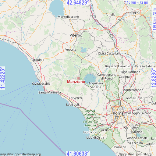
42° 7' 47.928" North, 12° 7' 31.332" East
| Map corner | latitude | longitude |
|---|---|---|
| Upper-left | 42.64929°, | 11.42225° |
| Center: | 42.12998°, | 12.12537° |
| Lower-right: | 41.60638°, | 12.8285° |
| Map W x H: | 116×116 km | = 72.1×72.1mi |
| max Lat: | 47.04031° ⇑69.2% North |
| Manziana: | 42.12998° |
| min Lat: | ⇓30.8% South 35.50142° |
| min Long | Manziana | max Long |
| 6.69888° | 12.12537° | 18.48682° |
| W 57.7%⇐ | ⇒42.3% E |
Elevation
Elevation of Manziana is 358 m = 1175 ft, and this is 51.3 m = 168 ft above average elevation for this country.
| Max E: |
2085 m = 6841 ft | 33.5% |
| Manziana | 358 m 1175 ft | |
| Avg. | 306.7 m = 1006 ft | |
Min E: |
-4 m = -13 ft | 66.5% |
See also: Italy elevation on elevation.city.
Geographical zone
Manziana is located in North temperate zone (between Tropic of Cancer and the Arctic Circle). Distance of this Northern Tropic circle is 2078.5 km =1291.5 mi to South.| Distance of | km | miles | from Manziana |
|---|---|---|---|
| North Pole | 5322.6 | 3307.3 | to North |
| Arctic Circle | 2716.8 | 1688.1 | to North |
| Tropic Cancer | 2078.5 | 1291.5 | to South |
| Equator | 4684.4 | 2910.8 | to South |


Nearby cities:
15 places around Manziana: (largest is in red/bold)
• Anguillara Sabazia
14.2 km =8.8 mi,  113°
113°
• Barbarano Romano
14.1 km =8.8 mi,  340°
340°
• Bassano Romano
11.5 km =7.1 mi,  26°
26°
• Bracciano
4.5 km =2.8 mi,  132°
132°
• Canale Monterano
2 km =1.2 mi,  289°
289°
• Capranica
14.8 km =9.2 mi,  15°
15°
• Cerveteri
15.7 km =9.8 mi,  190°
190°
• Colle Diana
16.2 km =10.1 mi, 26°
• Montevirginio
2 km =1.2 mi,  1°
1°
• Oriolo Romano
3.8 km =2.4 mi, 16°
• Ponton dell'Elce
15 km =9.3 mi,  142°
142°
• Sutri
14.9 km =9.3 mi, 30°
• Tolfa
16.1 km =10 mi,  278°
278°
• Trevignano Romano
9.9 km =6.2 mi,  70°
70°
• Vejano
10.2 km =6.3 mi,  345°
345°
Sources, notices
• [Note1] Compared only with cities in Italy existing in our database
• [Src1] Map data: © OpenStreetMap contributors (CC-BY-SA)
• [Src2] Other city data from geonames.org with taken over terms of usage.
• [Src3] Geographical zone / Annual Mean Temperature by Robert A. Rohde @ Wikipedia
