Loreggiola geodata
Loreggiola (Veneto) is a populated place; located in Italy in Europe/Rome (GMT+2) time zone. With population of 1,306 people, there are 5616 cities with bigger population in this country. Compared to other cities in Italy, 77.4% of cities are located further ↓South; 54.8% of cities are located further ←West and 86.4% of cities have higher elevation than Loreggiola. Note1


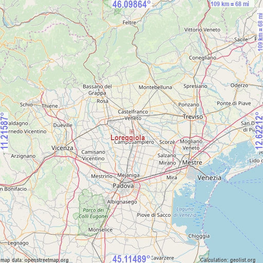
Loreggiola GPS coordinates[2]
45° 36' 32.112" North, 11° 55' 8.364" East
| Map corner | latitude | longitude |
|---|---|---|
| Upper-left | 46.09864°, | 11.21587° |
| Center: | 45.60892°, | 11.91899° |
| Lower-right: | 45.11489°, | 12.62212° |
| Map W x H: | 109.4×109.4 km | = 68×68mi |
| max Lat: | 47.04031° ⇑22.6% North |
| Loreggiola: | 45.60892° |
| min Lat: | ⇓77.4% South 35.50142° |
| min Long | Loreggiola | max Long |
| 6.69888° | 11.91899° | 18.48682° |
| W 54.8%⇐ | ⇒45.2% E |
Elevation
Elevation of Loreggiola is 27 m = 89 ft, and this is 279.7 m = 918 ft below average elevation for this country.
| Max E: |
2085 m = 6841 ft | 86.4% |
| Avg. | 306.7 m = 1006 ft | |
| Loreggiola | 27 m = 89 ft | |
Min E: |
-4 m = -13 ft | 13.6% |
See also: Italy elevation on elevation.city.
Geographical zone
Loreggiola is located in North temperate zone (between Tropic of Cancer and the Arctic Circle). Distance of this North polar circle is 2329.9 km =1447.7 mi to North.| Distance of | km | miles | from Loreggiola |
|---|---|---|---|
| North Pole | 4935.8 | 3067 | to North |
| Arctic Circle | 2329.9 | 1447.7 | to North |
| Tropic Cancer | 2465.3 | 1531.9 | to South |
| Equator | 5071.2 | 3151.1 | to South |


Nearby cities:
15 places around Loreggiola: (largest is in red/bold)
• Abbazia Pisani
5 km =3.1 mi,  274°
274°
• Camposampiero
5.2 km =3.2 mi,  165°
165°
• Castelfranco Veneto
7 km =4.3 mi,  5°
5°
• Castelminio
6.7 km =4.2 mi,  53°
53°
• Fossalta
7.5 km =4.7 mi,  119°
119°
• Loreggia
2.6 km =1.6 mi, 119°
• Piombino Dese
5.8 km =3.6 mi,  89°
89°
• Resana
4 km =2.5 mi,  43°
43°
• Ronchi
6.5 km =4 mi,  104°
104°
• Rustega
6.3 km =3.9 mi,  134°
134°
• San Martino di Lupari
6.6 km =4.1 mi,  315°
315°
• Sant'Andrea
4.5 km =2.8 mi,  337°
337°
• Sant'Anna Morosina
6.5 km =4 mi,  264°
264°
• Santa Giustina in Colle
4 km =2.5 mi,  201°
201°
• Villa del Conte
5.4 km =3.4 mi,  239°
239°
Sources, notices
• [Note1] Compared only with cities in Italy existing in our database
• [Src1] Map data: © OpenStreetMap contributors (CC-BY-SA)
• [Src2] Other city data from geonames.org with taken over terms of usage.
• [Src3] Geographical zone / Annual Mean Temperature by Robert A. Rohde @ Wikipedia
