Lomazzo geodata
Lomazzo (Lombardy) is a seat of a third-order administrative division; located in Italy in Europe/Rome (GMT+2) time zone. With population of 7,772 people, there are 1254 cities with bigger population in this country. Compared to other cities in Italy, 81% of cities are located further ↓South; 80.8% of cities are located further →East and 59% of cities have lower elevation than Lomazzo. Note1


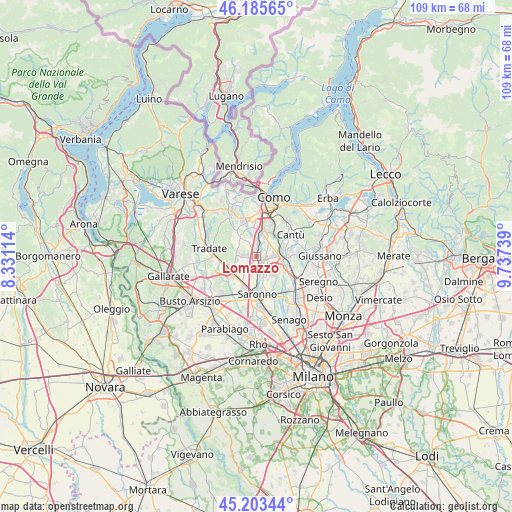
Lomazzo GPS coordinates[2]
45° 41' 48.12" North, 9° 2' 3.372" East
| Map corner | latitude | longitude |
|---|---|---|
| Upper-left | 46.18565°, | 8.33114° |
| Center: | 45.6967°, | 9.03427° |
| Lower-right: | 45.20344°, | 9.73739° |
| Map W x H: | 109.2×109.2 km | = 67.9×67.9mi |
| max Lat: | 47.04031° ⇑19% North |
| Lomazzo: | 45.6967° |
| min Lat: | ⇓81% South 35.50142° |
| min Long | Lomazzo | max Long |
| 6.69888° | 9.03427° | 18.48682° |
| W 19.2%⇐ | ⇒80.8% E |
Elevation
Elevation of Lomazzo is 292 m = 958 ft, and this is 14.7 m = 48 ft below average elevation for this country.
| Max E: |
2085 m = 6841 ft | 41% |
| Avg. | 306.7 m = 1006 ft | |
| Lomazzo | 292 m = 958 ft | |
Min E: |
-4 m = -13 ft | 59% |
See also: Italy elevation on elevation.city.
Geographical zone
Lomazzo is located in North temperate zone (between Tropic of Cancer and the Arctic Circle). Distance of this North polar circle is 2320.2 km =1441.7 mi to North.| Distance of | km | miles | from Lomazzo |
|---|---|---|---|
| North Pole | 4926.1 | 3060.9 | to North |
| Arctic Circle | 2320.2 | 1441.7 | to North |
| Tropic Cancer | 2475.1 | 1538 | to South |
| Equator | 5081 | 3157.2 | to South |


Nearby cities:
15 places around Lomazzo: (largest is in red/bold)
• Bregnano
2 km =1.2 mi,  86°
86°
• Bulgorello
3.5 km =2.2 mi,  27°
27°
• Cadorago-Caslino al Piano
3.4 km =2.1 mi,  4°
4°
• Cascina Restelli
3.9 km =2.4 mi,  242°
242°
• Cermenate
3.9 km =2.4 mi,  81°
81°
• Cirimido
1.7 km =1.1 mi,  281°
281°
• Fenegrò
2.7 km =1.7 mi, 281°
• Guanzate
3.6 km =2.2 mi,  341°
341°
• Limido Comasco
4.3 km =2.7 mi,  258°
258°
• Lurago Marinone
4.1 km =2.5 mi, 282°
• Manera
2.6 km =1.6 mi,  169°
169°
• Puginate
2.4 km =1.5 mi,  48°
48°
• Rovellasca
3.5 km =2.2 mi,  161°
161°
• San Michele-San Giorgio
1.9 km =1.2 mi, 92°
• Vertemate Con Minoprio
4.4 km =2.7 mi,  43°
43°
Sources, notices
• [Note1] Compared only with cities in Italy existing in our database
• [Src1] Map data: © OpenStreetMap contributors (CC-BY-SA)
• [Src2] Other city data from geonames.org with taken over terms of usage.
• [Src3] Geographical zone / Annual Mean Temperature by Robert A. Rohde @ Wikipedia
