Fumone geodata
Fumone (Latium) is a seat of a third-order administrative division; located in Italy in Europe/Rome (GMT+2) time zone. With population of 1,342 people, there are 5505 cities with bigger population in this country. Compared to other cities in Italy, 72.5% of cities are located further ↑North; 71.1% of cities are located further ←West and 88.4% of cities have lower elevation than Fumone. Note1


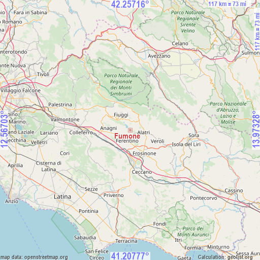
Fumone GPS coordinates[2]
41° 44' 4.596" North, 13° 16' 12.54" East
| Map corner | latitude | longitude |
|---|---|---|
| Upper-left | 42.25716°, | 12.56703° |
| Center: | 41.73461°, | 13.27015° |
| Lower-right: | 41.20777°, | 13.97328° |
| Map W x H: | 116.7×116.7 km | = 72.5×72.5mi |
| max Lat: | 47.04031° ⇑72.5% North |
| Fumone: | 41.73461° |
| min Lat: | ⇓27.5% South 35.50142° |
| min Long | Fumone | max Long |
| 6.69888° | 13.27015° | 18.48682° |
| W 71.1%⇐ | ⇒28.9% E |
Elevation
Elevation of Fumone is 679 m = 2228 ft, and this is 372.3 m = 1221 ft above average elevation for this country.
| Max E: |
2085 m = 6841 ft | 11.6% |
| Fumone | 679 m 2228 ft | |
| Avg. | 306.7 m = 1006 ft | |
Min E: |
-4 m = -13 ft | 88.4% |
See also: Italy elevation on elevation.city.
Geographical zone
Fumone is located in North temperate zone (between Tropic of Cancer and the Arctic Circle). Distance of this Northern Tropic circle is 2034.5 km =1264.2 mi to South.| Distance of | km | miles | from Fumone |
|---|---|---|---|
| North Pole | 5366.6 | 3334.6 | to North |
| Arctic Circle | 2760.7 | 1715.4 | to North |
| Tropic Cancer | 2034.5 | 1264.2 | to South |
| Equator | 4640.5 | 2883.5 | to South |


Nearby cities:
15 places around Fumone: (largest is in red/bold)
• Alatri
5.9 km =3.7 mi,  92°
92°
• Collelavena
4.8 km =3 mi,  60°
60°
• Ferentino
5 km =3.1 mi,  193°
193°
• Fiuggi
8 km =5 mi,  331°
331°
• Fontana Scurano
8 km =5 mi, 89°
• Fresine
7.6 km =4.7 mi, 190°
• Guarcino
8.1 km =5 mi,  27°
27°
• Monte San Marino
4.3 km =2.7 mi,  125°
125°
• Pitocco
5.9 km =3.7 mi,  40°
40°
• San Giovanni-Patoni
4.2 km =2.6 mi,  5°
5°
• Tofe
6.9 km =4.3 mi,  216°
216°
• Torre Caietani
5.8 km =3.6 mi,  355°
355°
• Trivigliano
4.6 km =2.9 mi,  2°
2°
• Tufano
5.3 km =3.3 mi,  265°
265°
• Vico nel Lazio
7.7 km =4.8 mi,  51°
51°
Sources, notices
• [Note1] Compared only with cities in Italy existing in our database
• [Src1] Map data: © OpenStreetMap contributors (CC-BY-SA)
• [Src2] Other city data from geonames.org with taken over terms of usage.
• [Src3] Geographical zone / Annual Mean Temperature by Robert A. Rohde @ Wikipedia
