Fallo geodata
Fallo (Abruzzo) is a seat of a third-order administrative division; located in Italy in Europe/Rome (GMT+2) time zone. With population of 162 people, there are 11243 cities with bigger population in this country. Compared to other cities in Italy, 70.9% of cities are located further ↑North; 81.1% of cities are located further ←West and 82.9% of cities have lower elevation than Fallo. Note1


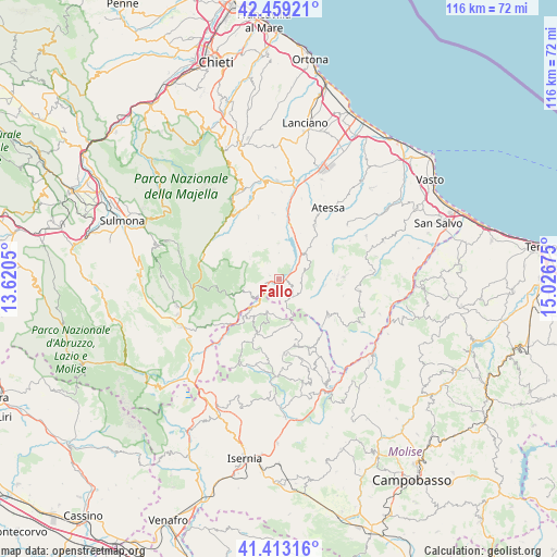
Fallo GPS coordinates[2]
41° 56' 17.988" North, 14° 19' 25.032" East
| Map corner | latitude | longitude |
|---|---|---|
| Upper-left | 42.45921°, | 13.6205° |
| Center: | 41.93833°, | 14.32362° |
| Lower-right: | 41.41316°, | 15.02675° |
| Map W x H: | 116.3×116.3 km | = 72.3×72.3mi |
| max Lat: | 47.04031° ⇑70.9% North |
| Fallo: | 41.93833° |
| min Lat: | ⇓29.1% South 35.50142° |
| min Long | Fallo | max Long |
| 6.69888° | 14.32362° | 18.48682° |
| W 81.1%⇐ | ⇒18.9% E |
Elevation
Elevation of Fallo is 571 m = 1873 ft, and this is 264.3 m = 867 ft above average elevation for this country.
| Max E: |
2085 m = 6841 ft | 17.1% |
| Fallo | 571 m 1873 ft | |
| Avg. | 306.7 m = 1006 ft | |
Min E: |
-4 m = -13 ft | 82.9% |
See also: Italy elevation on elevation.city.
Geographical zone
Fallo is located in North temperate zone (between Tropic of Cancer and the Arctic Circle). Distance of this Northern Tropic circle is 2057.2 km =1278.3 mi to South.| Distance of | km | miles | from Fallo |
|---|---|---|---|
| North Pole | 5344 | 3320.6 | to North |
| Arctic Circle | 2738.1 | 1701.4 | to North |
| Tropic Cancer | 2057.2 | 1278.3 | to South |
| Equator | 4663.1 | 2897.5 | to South |


Nearby cities:
15 places around Fallo: (largest is in red/bold)
• Borrello
2.8 km =1.7 mi,  212°
212°
• Civitaluparella
2 km =1.2 mi,  291°
291°
• Colledimezzo
7.5 km =4.7 mi,  44°
44°
• Montebello sul Sangro
5.4 km =3.4 mi,  0°
0°
• Monteferrante
5.6 km =3.5 mi,  72°
72°
• Montelapiano
3.1 km =1.9 mi,  29°
29°
• Montenerodomo
7.3 km =4.5 mi,  305°
305°
• Pennadomo
7.3 km =4.5 mi,  359°
359°
• Pescopennataro
7.2 km =4.5 mi,  200°
200°
• Pietraferrazzana
5.4 km =3.4 mi,  50°
50°
• Pizzoferrato
7.4 km =4.6 mi,  256°
256°
• Quadri
3.4 km =2.1 mi,  241°
241°
• Roio del Sangro
5.1 km =3.2 mi,  125°
125°
• Rosello
4.6 km =2.9 mi,  152°
152°
• Villa Santa Maria
2.7 km =1.7 mi,  57°
57°
Sources, notices
• [Note1] Compared only with cities in Italy existing in our database
• [Src1] Map data: © OpenStreetMap contributors (CC-BY-SA)
• [Src2] Other city data from geonames.org with taken over terms of usage.
• [Src3] Geographical zone / Annual Mean Temperature by Robert A. Rohde @ Wikipedia
