Domodossola geodata
Domodossola (Piedmont) is a seat of a third-order administrative division; located in Italy in Europe/Rome (GMT+2) time zone. With population of 17,778 people, there are 496 cities with bigger population in this country. Compared to other cities in Italy, 94.3% of cities are located further ↓South; 90.2% of cities are located further →East and 57.7% of cities have lower elevation than Domodossola. Note1
Administrative division(s):
- Level 1: Piedmont
- Level 2: Provincia Verbano-Cusio-Ossola
- Level 3: Domodossola


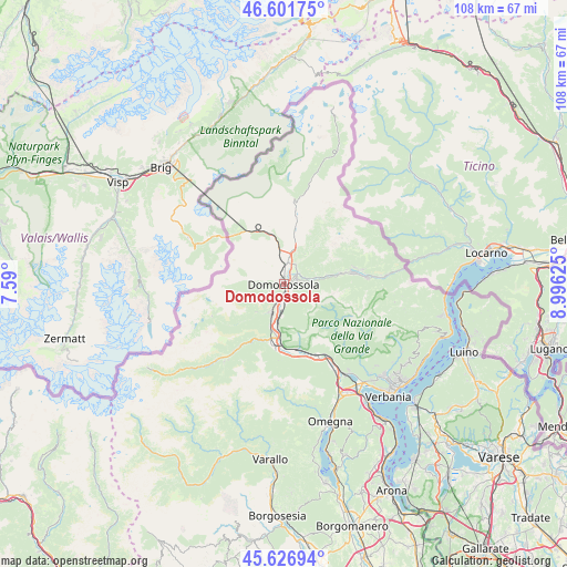
Domodossola GPS coordinates[2]
46° 6' 59.4" North, 8° 17' 35.268" East
| Map corner | latitude | longitude |
|---|---|---|
| Upper-left | 46.60175°, | 7.59° |
| Center: | 46.1165°, | 8.29313° |
| Lower-right: | 45.62694°, | 8.99625° |
| Map W x H: | 108.4×108.4 km | = 67.4×67.4mi |
| max Lat: | 47.04031° ⇑5.7% North |
| Domodossola: | 46.1165° |
| min Lat: | ⇓94.3% South 35.50142° |
| min Long | Domodossola | max Long |
| 6.69888° | 8.29313° | 18.48682° |
| W 9.8%⇐ | ⇒90.2% E |
Elevation
Elevation of Domodossola is 284 m = 932 ft, and this is 22.7 m = 74 ft below average elevation for this country.
| Max E: |
2085 m = 6841 ft | 42.3% |
| Avg. | 306.7 m = 1006 ft | |
| Domodossola | 284 m = 932 ft | |
Min E: |
-4 m = -13 ft | 57.7% |
See also: Italy elevation on elevation.city.
Geographical zone
Domodossola is located in North temperate zone (between Tropic of Cancer and the Arctic Circle). Distance of this North polar circle is 2273.5 km =1412.7 mi to North.| Distance of | km | miles | from Domodossola |
|---|---|---|---|
| North Pole | 4879.4 | 3031.9 | to North |
| Arctic Circle | 2273.5 | 1412.7 | to North |
| Tropic Cancer | 2521.8 | 1567 | to South |
| Equator | 5127.7 | 3186.2 | to South |


Nearby cities:
15 places around Domodossola: (largest is in red/bold)
• Beura
4.1 km =2.5 mi,  174°
174°
• Crevoladossola
3.6 km =2.2 mi,  5°
5°
• Croppo
1.9 km =1.2 mi,  142°
142°
• Masera
3.5 km =2.2 mi,  44°
44°
• Montecrestese
5.9 km =3.7 mi,  25°
25°
• Montescheno
7.3 km =4.5 mi,  220°
220°
• Pallanzeno
8.7 km =5.4 mi,  197°
197°
• Piedimulera
10.6 km =6.6 mi,  194°
194°
• Pontetto-Roldo
4.5 km =2.8 mi, 28°
• San Lorenzo
7.2 km =4.5 mi,  279°
279°
• Seppiana
8.8 km =5.5 mi, 222°
• Trontano
3.2 km =2 mi,  77°
77°
• Varzo
10.6 km =6.6 mi,  342°
342°
• Viganella
10.5 km =6.5 mi,  226°
226°
• Villadossola
5.5 km =3.4 mi, 201°
Sources, notices
• [Note1] Compared only with cities in Italy existing in our database
• [Src1] Map data: © OpenStreetMap contributors (CC-BY-SA)
• [Src2] Other city data from geonames.org with taken over terms of usage.
• [Src3] Geographical zone / Annual Mean Temperature by Robert A. Rohde @ Wikipedia
